You are here: Home > Network List > TA - USArray Transportable Network (new EarthScope stations) Stations List
> Station O03E Paynes Creek, CA, USA > Earthquake Result Viewer
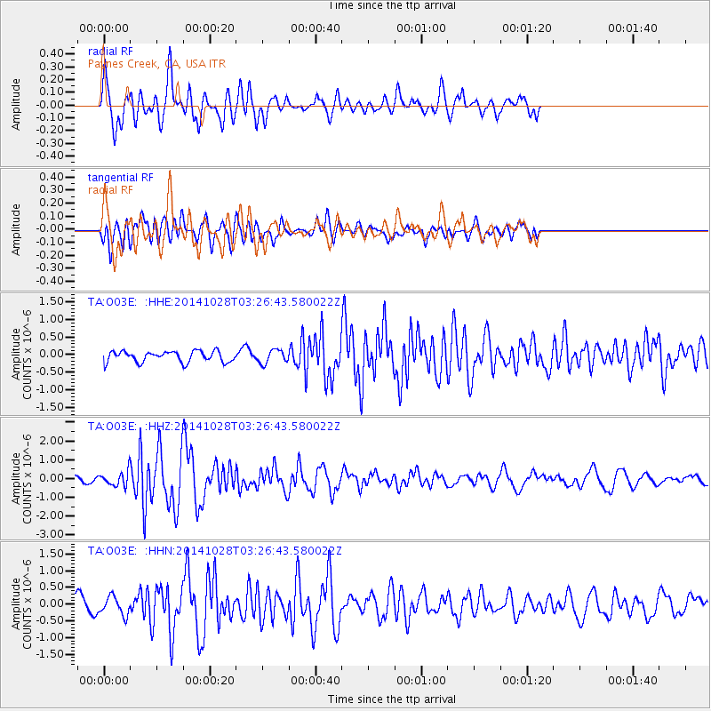
O03E Paynes Creek, CA, USA - Earthquake Result Viewer
*The percent match for this event was below the threshold and hence no stack was calculated.
| Earthquake location: |
Tonga Islands |
| Earthquake latitude/longitude: |
-15.2/-174.7 |
| Earthquake time(UTC): |
2014/10/28 (301) 03:15:43 GMT |
| Earthquake Depth: |
35 km |
| Earthquake Magnitude: |
5.5 MB, 6.1 MWC |
| Earthquake Catalog/Contributor: |
NEIC PDE/NEIC COMCAT |
|
| Network: |
TA USArray Transportable Network (new EarthScope stations) |
| Station: |
O03E Paynes Creek, CA, USA |
| Lat/Lon: |
40.29 N/121.80 W |
| Elevation: |
967 m |
|
| Distance: |
73.9 deg |
| Az: |
39.404 deg |
| Baz: |
233.253 deg |
| Ray Param: |
$rayparam |
*The percent match for this event was below the threshold and hence was not used in the summary stack. |
|
| Radial Match: |
82.02131 % |
| Radial Bump: |
400 |
| Transverse Match: |
63.97777 % |
| Transverse Bump: |
400 |
| SOD ConfigId: |
811962 |
| Insert Time: |
2014-11-11 03:56:15.720 +0000 |
| GWidth: |
2.5 |
| Max Bumps: |
400 |
| Tol: |
0.001 |
|
Signal To Noise
| Channel | StoN | STA | LTA |
| TA:O03E: :HHZ:20141028T03:26:43.580022Z | 1.9938284 | 3.5755204E-7 | 1.793294E-7 |
| TA:O03E: :HHN:20141028T03:26:43.580022Z | 1.2604018 | 2.821198E-7 | 2.2383323E-7 |
| TA:O03E: :HHE:20141028T03:26:43.580022Z | 1.1995097 | 1.8902182E-7 | 1.5758255E-7 |
| Arrivals |
| Ps | |
| PpPs | |
| PsPs/PpSs | |


