You are here: Home > Network List > US - United States National Seismic Network Stations List
> Station EGMT Eagleton, Montana, USA > Earthquake Result Viewer
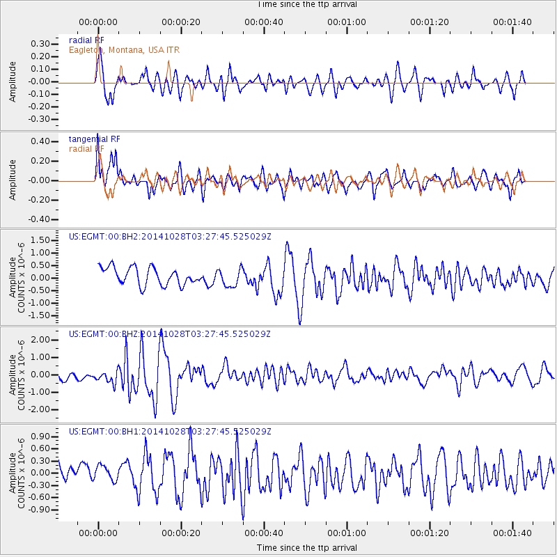
EGMT Eagleton, Montana, USA - Earthquake Result Viewer
*The percent match for this event was below the threshold and hence no stack was calculated.
| Earthquake location: |
Tonga Islands |
| Earthquake latitude/longitude: |
-15.2/-174.7 |
| Earthquake time(UTC): |
2014/10/28 (301) 03:15:43 GMT |
| Earthquake Depth: |
35 km |
| Earthquake Magnitude: |
5.5 MB, 6.1 MWC |
| Earthquake Catalog/Contributor: |
NEIC PDE/NEIC COMCAT |
|
| Network: |
US United States National Seismic Network |
| Station: |
EGMT Eagleton, Montana, USA |
| Lat/Lon: |
48.02 N/109.75 W |
| Elevation: |
1055 m |
|
| Distance: |
85.3 deg |
| Az: |
37.59 deg |
| Baz: |
241.323 deg |
| Ray Param: |
$rayparam |
*The percent match for this event was below the threshold and hence was not used in the summary stack. |
|
| Radial Match: |
77.34168 % |
| Radial Bump: |
400 |
| Transverse Match: |
70.923965 % |
| Transverse Bump: |
400 |
| SOD ConfigId: |
811962 |
| Insert Time: |
2014-11-11 03:57:46.812 +0000 |
| GWidth: |
2.5 |
| Max Bumps: |
400 |
| Tol: |
0.001 |
|
Signal To Noise
| Channel | StoN | STA | LTA |
| US:EGMT:00:BHZ:20141028T03:27:45.525029Z | 1.2653751 | 4.377461E-7 | 3.4594177E-7 |
| US:EGMT:00:BH1:20141028T03:27:45.525029Z | 0.64666986 | 2.8259478E-7 | 4.370001E-7 |
| US:EGMT:00:BH2:20141028T03:27:45.525029Z | 1.0698241 | 3.6986114E-7 | 3.4572145E-7 |
| Arrivals |
| Ps | |
| PpPs | |
| PsPs/PpSs | |


