You are here: Home > Network List > US - United States National Seismic Network Stations List
> Station WMOK Wichita Mountains, Oklahoma, USA > Earthquake Result Viewer
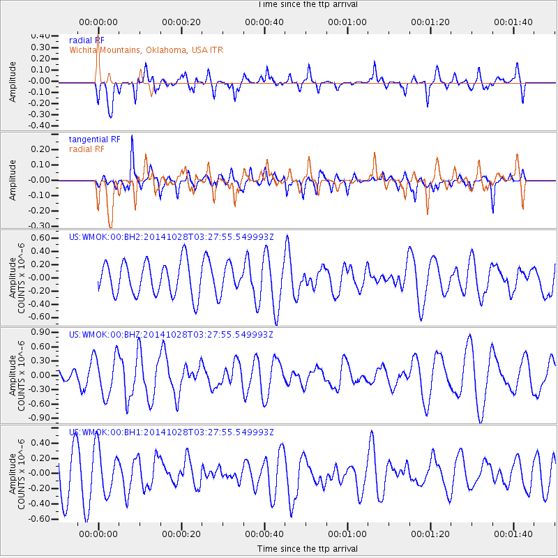
WMOK Wichita Mountains, Oklahoma, USA - Earthquake Result Viewer
*The percent match for this event was below the threshold and hence no stack was calculated.
| Earthquake location: |
Tonga Islands |
| Earthquake latitude/longitude: |
-15.2/-174.7 |
| Earthquake time(UTC): |
2014/10/28 (301) 03:15:43 GMT |
| Earthquake Depth: |
35 km |
| Earthquake Magnitude: |
5.5 MB, 6.1 MWC |
| Earthquake Catalog/Contributor: |
NEIC PDE/NEIC COMCAT |
|
| Network: |
US United States National Seismic Network |
| Station: |
WMOK Wichita Mountains, Oklahoma, USA |
| Lat/Lon: |
34.74 N/98.78 W |
| Elevation: |
486 m |
|
| Distance: |
87.4 deg |
| Az: |
53.086 deg |
| Baz: |
249.61 deg |
| Ray Param: |
$rayparam |
*The percent match for this event was below the threshold and hence was not used in the summary stack. |
|
| Radial Match: |
66.24275 % |
| Radial Bump: |
400 |
| Transverse Match: |
33.828625 % |
| Transverse Bump: |
400 |
| SOD ConfigId: |
811962 |
| Insert Time: |
2014-11-11 03:58:25.747 +0000 |
| GWidth: |
2.5 |
| Max Bumps: |
400 |
| Tol: |
0.001 |
|
Signal To Noise
| Channel | StoN | STA | LTA |
| US:WMOK:00:BHZ:20141028T03:27:55.549993Z | 2.416367 | 4.2627923E-7 | 1.7641328E-7 |
| US:WMOK:00:BH1:20141028T03:27:55.549993Z | 0.9934472 | 3.1841486E-7 | 3.2051514E-7 |
| US:WMOK:00:BH2:20141028T03:27:55.549993Z | 0.7899578 | 1.961158E-7 | 2.482611E-7 |
| Arrivals |
| Ps | |
| PpPs | |
| PsPs/PpSs | |


