You are here: Home > Network List > CO - South Carolina Seismic Network Stations List
> Station PAULI Pauline, SC, USA > Earthquake Result Viewer
PAULI Pauline, SC, USA - Earthquake Result Viewer
| Earthquake location: |
Iceland |
| Earthquake latitude/longitude: |
64.5/-17.2 |
| Earthquake time(UTC): |
2014/10/07 (280) 10:22:31 GMT |
| Earthquake Depth: |
10 km |
| Earthquake Magnitude: |
5.5 MWW, 5.4 MWB, 5.5 MWC |
| Earthquake Catalog/Contributor: |
NEIC PDE/NEIC COMCAT |
|
| Network: |
CO South Carolina Seismic Network |
| Station: |
PAULI Pauline, SC, USA |
| Lat/Lon: |
34.82 N/81.81 W |
| Elevation: |
179 m |
|
| Distance: |
48.3 deg |
| Az: |
264.47 deg |
| Baz: |
31.562 deg |
| Ray Param: |
0.06943985 |
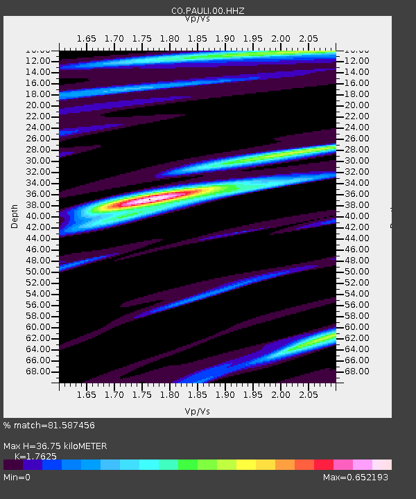
| Estimated Moho Depth: |
36.75 km |
| Estimated Crust Vp/Vs: |
1.76 |
| Assumed Crust Vp: |
6.419 km/s |
| Estimated Crust Vs: |
3.642 km/s |
| Estimated Crust Poisson's Ratio: |
0.26 |
|
| Radial Match: |
81.587456 % |
| Radial Bump: |
354 |
| Transverse Match: |
61.310238 % |
| Transverse Bump: |
400 |
| SOD ConfigId: |
812614 |
| Insert Time: |
2014-11-12 13:43:17.807 +0000 |
| GWidth: |
2.5 |
| Max Bumps: |
400 |
| Tol: |
0.001 |
|

Signal To Noise
| Channel | StoN | STA | LTA |
| CO:PAULI:00:HHZ:20141007T10:30:42.070Z | 5.085866 | 4.9953394E-7 | 9.8220035E-8 |
| CO:PAULI:00:HHN:20141007T10:30:42.070Z | 2.6131868 | 1.911191E-7 | 7.313641E-8 |
| CO:PAULI:00:HHE:20141007T10:30:42.070Z | 1.6567619 | 1.2857433E-7 | 7.76058E-8 |
| Arrivals |
| Ps | 4.6 SECOND |
| PpPs | 15 SECOND |
| PsPs/PpSs | 20 SECOND |


