You are here: Home > Network List > TA - USArray Transportable Network (new EarthScope stations) Stations List
> Station P58A Pank, Wackersville, MD, USA > Earthquake Result Viewer
P58A Pank, Wackersville, MD, USA - Earthquake Result Viewer
| Earthquake location: |
Iceland |
| Earthquake latitude/longitude: |
64.5/-17.2 |
| Earthquake time(UTC): |
2014/10/07 (280) 10:22:31 GMT |
| Earthquake Depth: |
10 km |
| Earthquake Magnitude: |
5.5 MWW, 5.4 MWB, 5.5 MWC |
| Earthquake Catalog/Contributor: |
NEIC PDE/NEIC COMCAT |
|
| Network: |
TA USArray Transportable Network (new EarthScope stations) |
| Station: |
P58A Pank, Wackersville, MD, USA |
| Lat/Lon: |
39.49 N/77.30 W |
| Elevation: |
139 m |
|
| Distance: |
42.4 deg |
| Az: |
263.735 deg |
| Baz: |
33.762 deg |
| Ray Param: |
0.07316872 |
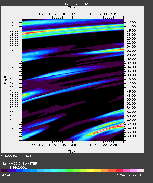
| Estimated Moho Depth: |
65.0 km |
| Estimated Crust Vp/Vs: |
1.99 |
| Assumed Crust Vp: |
6.419 km/s |
| Estimated Crust Vs: |
3.222 km/s |
| Estimated Crust Poisson's Ratio: |
0.33 |
|
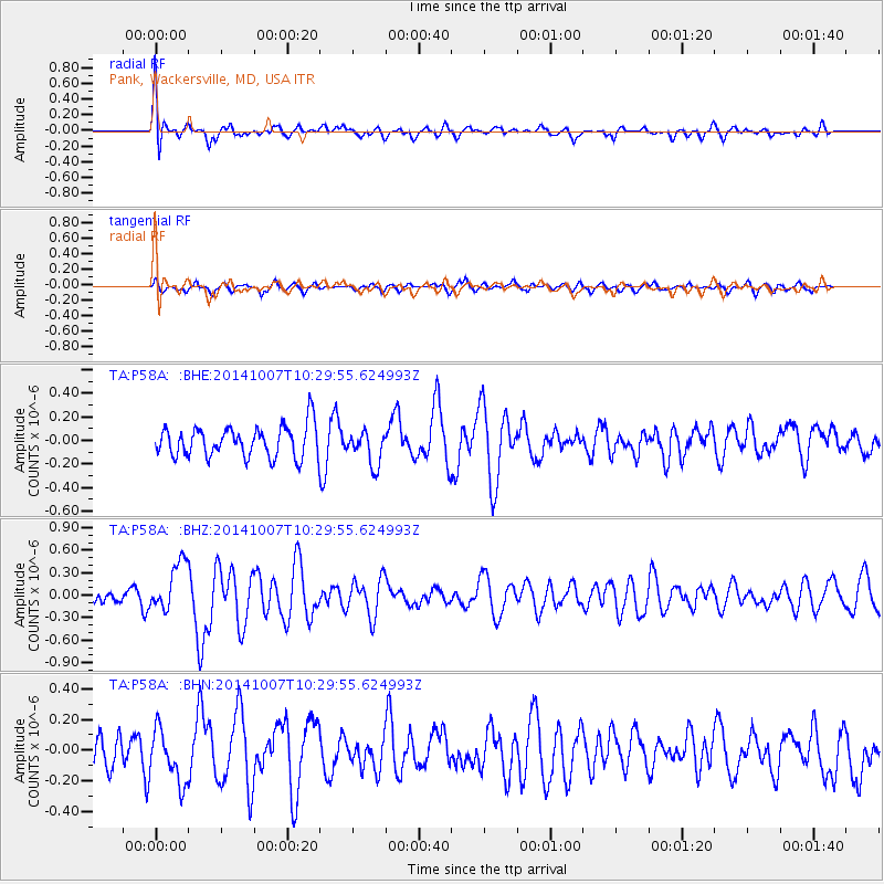
| Radial Match: |
80.89401 % |
| Radial Bump: |
400 |
| Transverse Match: |
46.655914 % |
| Transverse Bump: |
400 |
| SOD ConfigId: |
812614 |
| Insert Time: |
2014-11-12 14:07:50.479 +0000 |
| GWidth: |
2.5 |
| Max Bumps: |
400 |
| Tol: |
0.001 |
|
Signal To Noise
| Channel | StoN | STA | LTA |
| TA:P58A: :BHZ:20141007T10:29:55.624993Z | 2.953541 | 3.291777E-7 | 1.1145188E-7 |
| TA:P58A: :BHN:20141007T10:29:55.624993Z | 2.1523175 | 1.748192E-7 | 8.12237E-8 |
| TA:P58A: :BHE:20141007T10:29:55.624993Z | 1.0859714 | 1.4270374E-7 | 1.3140655E-7 |
| Arrivals |
| Ps | 11 SECOND |
| PpPs | 29 SECOND |
| PsPs/PpSs | 39 SECOND |


