You are here: Home > Network List > TA - USArray Transportable Network (new EarthScope stations) Stations List
> Station R54A Victor, WV, USA > Earthquake Result Viewer
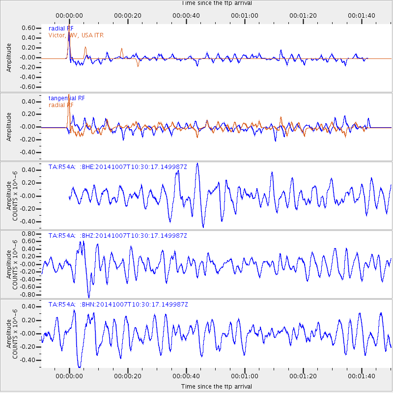
R54A Victor, WV, USA - Earthquake Result Viewer
*The percent match for this event was below the threshold and hence no stack was calculated.
| Earthquake location: |
Iceland |
| Earthquake latitude/longitude: |
64.5/-17.2 |
| Earthquake time(UTC): |
2014/10/07 (280) 10:22:31 GMT |
| Earthquake Depth: |
10 km |
| Earthquake Magnitude: |
5.5 MWW, 5.4 MWB, 5.5 MWC |
| Earthquake Catalog/Contributor: |
NEIC PDE/NEIC COMCAT |
|
| Network: |
TA USArray Transportable Network (new EarthScope stations) |
| Station: |
R54A Victor, WV, USA |
| Lat/Lon: |
38.18 N/80.99 W |
| Elevation: |
512 m |
|
| Distance: |
45.1 deg |
| Az: |
266.167 deg |
| Baz: |
33.214 deg |
| Ray Param: |
$rayparam |
*The percent match for this event was below the threshold and hence was not used in the summary stack. |
|
| Radial Match: |
63.26126 % |
| Radial Bump: |
400 |
| Transverse Match: |
55.026226 % |
| Transverse Bump: |
397 |
| SOD ConfigId: |
812614 |
| Insert Time: |
2014-11-12 14:08:33.484 +0000 |
| GWidth: |
2.5 |
| Max Bumps: |
400 |
| Tol: |
0.001 |
|
Signal To Noise
| Channel | StoN | STA | LTA |
| TA:R54A: :BHZ:20141007T10:30:17.149987Z | 2.6546676 | 3.2435705E-7 | 1.2218368E-7 |
| TA:R54A: :BHN:20141007T10:30:17.149987Z | 3.302791 | 2.8722422E-7 | 8.696409E-8 |
| TA:R54A: :BHE:20141007T10:30:17.149987Z | 2.1431963 | 1.7483715E-7 | 8.157776E-8 |
| Arrivals |
| Ps | |
| PpPs | |
| PsPs/PpSs | |


