You are here: Home > Network List > TA - USArray Transportable Network (new EarthScope stations) Stations List
> Station R56A Bull Pasture Mountain, McDowell, VA, USA > Earthquake Result Viewer
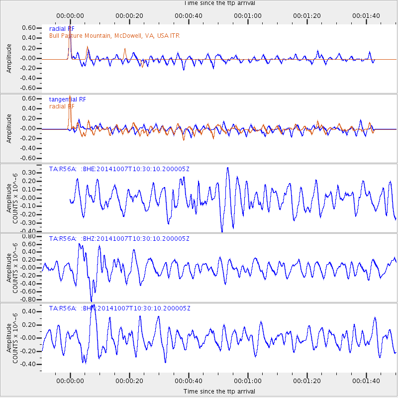
R56A Bull Pasture Mountain, McDowell, VA, USA - Earthquake Result Viewer
*The percent match for this event was below the threshold and hence no stack was calculated.
| Earthquake location: |
Iceland |
| Earthquake latitude/longitude: |
64.5/-17.2 |
| Earthquake time(UTC): |
2014/10/07 (280) 10:22:31 GMT |
| Earthquake Depth: |
10 km |
| Earthquake Magnitude: |
5.5 MWW, 5.4 MWB, 5.5 MWC |
| Earthquake Catalog/Contributor: |
NEIC PDE/NEIC COMCAT |
|
| Network: |
TA USArray Transportable Network (new EarthScope stations) |
| Station: |
R56A Bull Pasture Mountain, McDowell, VA, USA |
| Lat/Lon: |
38.41 N/79.40 W |
| Elevation: |
902 m |
|
| Distance: |
44.3 deg |
| Az: |
264.857 deg |
| Baz: |
33.262 deg |
| Ray Param: |
$rayparam |
*The percent match for this event was below the threshold and hence was not used in the summary stack. |
|
| Radial Match: |
68.87487 % |
| Radial Bump: |
400 |
| Transverse Match: |
50.361023 % |
| Transverse Bump: |
400 |
| SOD ConfigId: |
812614 |
| Insert Time: |
2014-11-12 14:08:38.998 +0000 |
| GWidth: |
2.5 |
| Max Bumps: |
400 |
| Tol: |
0.001 |
|
Signal To Noise
| Channel | StoN | STA | LTA |
| TA:R56A: :BHZ:20141007T10:30:10.200005Z | 3.6763933 | 3.4878278E-7 | 9.487091E-8 |
| TA:R56A: :BHN:20141007T10:30:10.200005Z | 1.6284752 | 1.4596739E-7 | 8.9634405E-8 |
| TA:R56A: :BHE:20141007T10:30:10.200005Z | 1.4258178 | 1.4988308E-7 | 1.05120776E-7 |
| Arrivals |
| Ps | |
| PpPs | |
| PsPs/PpSs | |


