You are here: Home > Network List > TA - USArray Transportable Network (new EarthScope stations) Stations List
> Station U57A Blanch, NC, USA > Earthquake Result Viewer
U57A Blanch, NC, USA - Earthquake Result Viewer
| Earthquake location: |
Iceland |
| Earthquake latitude/longitude: |
64.5/-17.2 |
| Earthquake time(UTC): |
2014/10/07 (280) 10:22:31 GMT |
| Earthquake Depth: |
10 km |
| Earthquake Magnitude: |
5.5 MWW, 5.4 MWB, 5.5 MWC |
| Earthquake Catalog/Contributor: |
NEIC PDE/NEIC COMCAT |
|
| Network: |
TA USArray Transportable Network (new EarthScope stations) |
| Station: |
U57A Blanch, NC, USA |
| Lat/Lon: |
36.43 N/79.34 W |
| Elevation: |
178 m |
|
| Distance: |
45.9 deg |
| Az: |
263.289 deg |
| Baz: |
32.195 deg |
| Ray Param: |
0.07098722 |
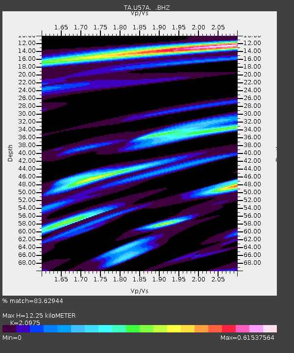
| Estimated Moho Depth: |
12.25 km |
| Estimated Crust Vp/Vs: |
2.10 |
| Assumed Crust Vp: |
6.419 km/s |
| Estimated Crust Vs: |
3.06 km/s |
| Estimated Crust Poisson's Ratio: |
0.35 |
|
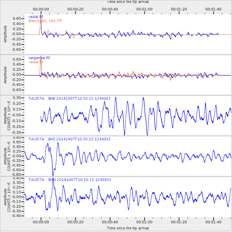
| Radial Match: |
83.62944 % |
| Radial Bump: |
400 |
| Transverse Match: |
51.170517 % |
| Transverse Bump: |
400 |
| SOD ConfigId: |
812614 |
| Insert Time: |
2014-11-12 14:11:02.272 +0000 |
| GWidth: |
2.5 |
| Max Bumps: |
400 |
| Tol: |
0.001 |
|
Signal To Noise
| Channel | StoN | STA | LTA |
| TA:U57A: :BHZ:20141007T10:30:23.124993Z | 2.6171935 | 2.7719847E-7 | 1.05914395E-7 |
| TA:U57A: :BHN:20141007T10:30:23.124993Z | 2.1857626 | 1.5195639E-7 | 6.952099E-8 |
| TA:U57A: :BHE:20141007T10:30:23.124993Z | 2.1631625 | 1.4341002E-7 | 6.629646E-8 |
| Arrivals |
| Ps | 2.2 SECOND |
| PpPs | 5.6 SECOND |
| PsPs/PpSs | 7.8 SECOND |


