You are here: Home > Network List > TA - USArray Transportable Network (new EarthScope stations) Stations List
> Station V55A Taylorsville, NC, USA > Earthquake Result Viewer
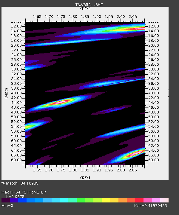
V55A Taylorsville, NC, USA - Earthquake Result Viewer
| Earthquake location: |
Iceland |
| Earthquake latitude/longitude: |
64.5/-17.2 |
| Earthquake time(UTC): |
2014/10/07 (280) 10:22:31 GMT |
| Earthquake Depth: |
10 km |
| Earthquake Magnitude: |
5.5 MWW, 5.4 MWB, 5.5 MWC |
| Earthquake Catalog/Contributor: |
NEIC PDE/NEIC COMCAT |
|
| Network: |
TA USArray Transportable Network (new EarthScope stations) |
| Station: |
V55A Taylorsville, NC, USA |
| Lat/Lon: |
35.85 N/81.21 W |
| Elevation: |
306 m |
|
| Distance: |
47.2 deg |
| Az: |
264.639 deg |
| Baz: |
32.021 deg |
| Ray Param: |
0.07015962 |
| Estimated Moho Depth: |
64.75 km |
| Estimated Crust Vp/Vs: |
2.07 |
| Assumed Crust Vp: |
6.419 km/s |
| Estimated Crust Vs: |
3.105 km/s |
| Estimated Crust Poisson's Ratio: |
0.35 |
|
| Radial Match: |
84.10935 % |
| Radial Bump: |
400 |
| Transverse Match: |
67.3277 % |
| Transverse Bump: |
400 |
| SOD ConfigId: |
812614 |
| Insert Time: |
2014-11-12 14:11:16.410 +0000 |
| GWidth: |
2.5 |
| Max Bumps: |
400 |
| Tol: |
0.001 |
|

Signal To Noise
| Channel | StoN | STA | LTA |
| TA:V55A: :BHZ:20141007T10:30:33.300011Z | 2.7173681 | 3.5023223E-7 | 1.2888655E-7 |
| TA:V55A: :BHN:20141007T10:30:33.300011Z | 2.1145065 | 1.7897902E-7 | 8.4643396E-8 |
| TA:V55A: :BHE:20141007T10:30:33.300011Z | 1.0552508 | 6.975554E-8 | 6.610328E-8 |
| Arrivals |
| Ps | 11 SECOND |
| PpPs | 29 SECOND |
| PsPs/PpSs | 41 SECOND |


