You are here: Home > Network List > TA - USArray Transportable Network (new EarthScope stations) Stations List
> Station V56A Mocksville, NC, USA > Earthquake Result Viewer
V56A Mocksville, NC, USA - Earthquake Result Viewer
| Earthquake location: |
Iceland |
| Earthquake latitude/longitude: |
64.5/-17.2 |
| Earthquake time(UTC): |
2014/10/07 (280) 10:22:31 GMT |
| Earthquake Depth: |
10 km |
| Earthquake Magnitude: |
5.5 MWW, 5.4 MWB, 5.5 MWC |
| Earthquake Catalog/Contributor: |
NEIC PDE/NEIC COMCAT |
|
| Network: |
TA USArray Transportable Network (new EarthScope stations) |
| Station: |
V56A Mocksville, NC, USA |
| Lat/Lon: |
35.81 N/80.50 W |
| Elevation: |
237 m |
|
| Distance: |
46.9 deg |
| Az: |
263.932 deg |
| Baz: |
31.958 deg |
| Ray Param: |
0.07034198 |
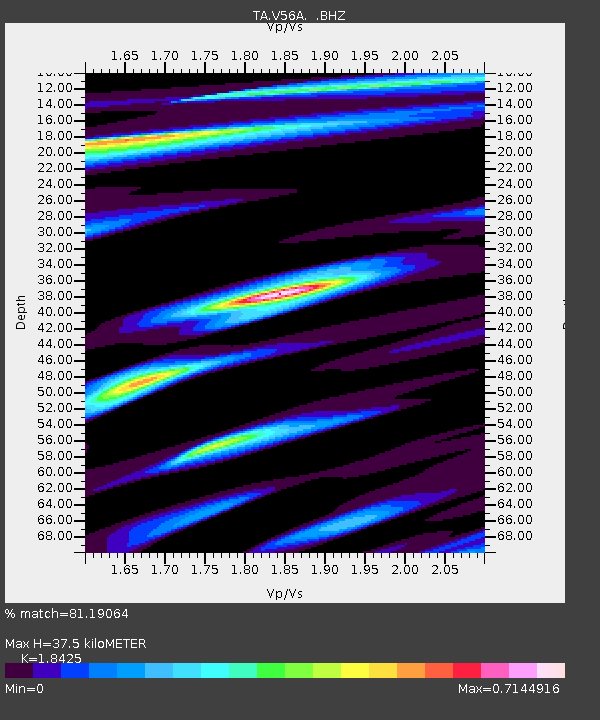
| Estimated Moho Depth: |
37.5 km |
| Estimated Crust Vp/Vs: |
1.84 |
| Assumed Crust Vp: |
6.419 km/s |
| Estimated Crust Vs: |
3.484 km/s |
| Estimated Crust Poisson's Ratio: |
0.29 |
|
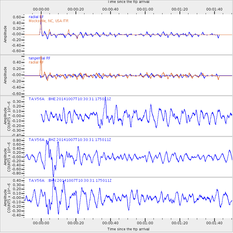
| Radial Match: |
81.19064 % |
| Radial Bump: |
290 |
| Transverse Match: |
60.92189 % |
| Transverse Bump: |
400 |
| SOD ConfigId: |
812614 |
| Insert Time: |
2014-11-12 14:11:23.010 +0000 |
| GWidth: |
2.5 |
| Max Bumps: |
400 |
| Tol: |
0.001 |
|
Signal To Noise
| Channel | StoN | STA | LTA |
| TA:V56A: :BHZ:20141007T10:30:31.175011Z | 5.518976 | 4.5175565E-7 | 8.185497E-8 |
| TA:V56A: :BHN:20141007T10:30:31.175011Z | 1.7120882 | 1.5524334E-7 | 9.0674845E-8 |
| TA:V56A: :BHE:20141007T10:30:31.175011Z | 1.5740944 | 1.14242354E-7 | 7.2576555E-8 |
| Arrivals |
| Ps | 5.2 SECOND |
| PpPs | 16 SECOND |
| PsPs/PpSs | 21 SECOND |


