You are here: Home > Network List > TA - USArray Transportable Network (new EarthScope stations) Stations List
> Station V61A Roper, NC, USA > Earthquake Result Viewer
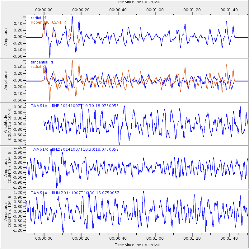
V61A Roper, NC, USA - Earthquake Result Viewer
*The percent match for this event was below the threshold and hence no stack was calculated.
| Earthquake location: |
Iceland |
| Earthquake latitude/longitude: |
64.5/-17.2 |
| Earthquake time(UTC): |
2014/10/07 (280) 10:22:31 GMT |
| Earthquake Depth: |
10 km |
| Earthquake Magnitude: |
5.5 MWW, 5.4 MWB, 5.5 MWC |
| Earthquake Catalog/Contributor: |
NEIC PDE/NEIC COMCAT |
|
| Network: |
TA USArray Transportable Network (new EarthScope stations) |
| Station: |
V61A Roper, NC, USA |
| Lat/Lon: |
35.79 N/76.58 W |
| Elevation: |
4.0 m |
|
| Distance: |
45.2 deg |
| Az: |
260.159 deg |
| Baz: |
31.623 deg |
| Ray Param: |
$rayparam |
*The percent match for this event was below the threshold and hence was not used in the summary stack. |
|
| Radial Match: |
64.63457 % |
| Radial Bump: |
340 |
| Transverse Match: |
59.029705 % |
| Transverse Bump: |
353 |
| SOD ConfigId: |
812614 |
| Insert Time: |
2014-11-12 14:11:34.897 +0000 |
| GWidth: |
2.5 |
| Max Bumps: |
400 |
| Tol: |
0.001 |
|
Signal To Noise
| Channel | StoN | STA | LTA |
| TA:V61A: :BHZ:20141007T10:30:18.075005Z | 2.019735 | 5.10906E-7 | 2.529569E-7 |
| TA:V61A: :BHN:20141007T10:30:18.075005Z | 1.1331844 | 4.6831403E-7 | 4.1327257E-7 |
| TA:V61A: :BHE:20141007T10:30:18.075005Z | 1.0983733 | 3.7008863E-7 | 3.3694252E-7 |
| Arrivals |
| Ps | |
| PpPs | |
| PsPs/PpSs | |


