You are here: Home > Network List > AV - Alaska Volcano Observatory Stations List
> Station AMKA Regional Station, Amchitka Island, Alaska > Earthquake Result Viewer
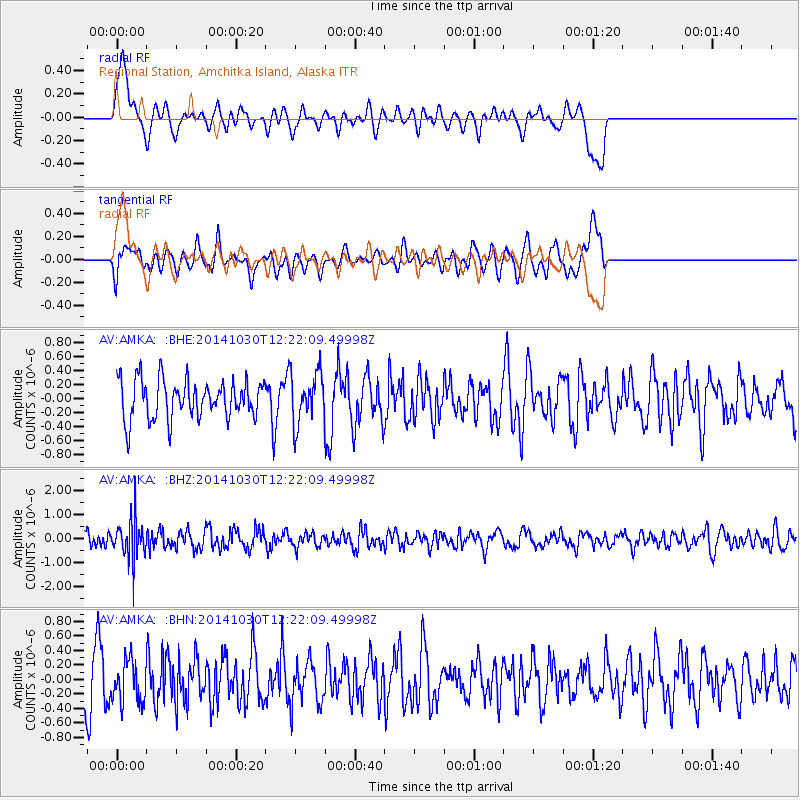
AMKA Regional Station, Amchitka Island, Alaska - Earthquake Result Viewer
*The percent match for this event was below the threshold and hence no stack was calculated.
| Earthquake location: |
Bali Sea |
| Earthquake latitude/longitude: |
-7.0/117.6 |
| Earthquake time(UTC): |
2014/10/30 (303) 12:11:36 GMT |
| Earthquake Depth: |
546 km |
| Earthquake Magnitude: |
5.7 MB |
| Earthquake Catalog/Contributor: |
NEIC PDE/NEIC COMCAT |
|
| Network: |
AV Alaska Volcano Observatory |
| Station: |
AMKA Regional Station, Amchitka Island, Alaska |
| Lat/Lon: |
51.38 N/179.30 E |
| Elevation: |
116 m |
|
| Distance: |
78.4 deg |
| Az: |
34.286 deg |
| Baz: |
243.16 deg |
| Ray Param: |
$rayparam |
*The percent match for this event was below the threshold and hence was not used in the summary stack. |
|
| Radial Match: |
54.72168 % |
| Radial Bump: |
400 |
| Transverse Match: |
47.254757 % |
| Transverse Bump: |
400 |
| SOD ConfigId: |
812614 |
| Insert Time: |
2014-11-13 12:21:51.721 +0000 |
| GWidth: |
2.5 |
| Max Bumps: |
400 |
| Tol: |
0.001 |
|
Signal To Noise
| Channel | StoN | STA | LTA |
| AV:AMKA: :BHZ:20141030T12:22:09.49998Z | 2.9709995 | 8.085657E-7 | 2.7215276E-7 |
| AV:AMKA: :BHN:20141030T12:22:09.49998Z | 0.80508065 | 2.8430247E-7 | 3.531354E-7 |
| AV:AMKA: :BHE:20141030T12:22:09.49998Z | 1.312044 | 3.644703E-7 | 2.7778816E-7 |
| Arrivals |
| Ps | |
| PpPs | |
| PsPs/PpSs | |


