You are here: Home > Network List > IU - Global Seismograph Network (GSN - IRIS/USGS) Stations List
> Station GUMO Guam, Mariana Islands > Earthquake Result Viewer
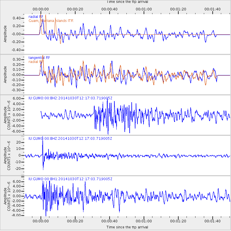
GUMO Guam, Mariana Islands - Earthquake Result Viewer
*The percent match for this event was below the threshold and hence no stack was calculated.
| Earthquake location: |
Bali Sea |
| Earthquake latitude/longitude: |
-7.0/117.6 |
| Earthquake time(UTC): |
2014/10/30 (303) 12:11:36 GMT |
| Earthquake Depth: |
546 km |
| Earthquake Magnitude: |
5.7 MB |
| Earthquake Catalog/Contributor: |
NEIC PDE/NEIC COMCAT |
|
| Network: |
IU Global Seismograph Network (GSN - IRIS/USGS) |
| Station: |
GUMO Guam, Mariana Islands |
| Lat/Lon: |
13.59 N/144.87 E |
| Elevation: |
170 m |
|
| Distance: |
33.9 deg |
| Az: |
52.974 deg |
| Baz: |
234.593 deg |
| Ray Param: |
$rayparam |
*The percent match for this event was below the threshold and hence was not used in the summary stack. |
|
| Radial Match: |
62.804943 % |
| Radial Bump: |
400 |
| Transverse Match: |
58.450424 % |
| Transverse Bump: |
400 |
| SOD ConfigId: |
812614 |
| Insert Time: |
2014-11-13 12:25:19.416 +0000 |
| GWidth: |
2.5 |
| Max Bumps: |
400 |
| Tol: |
0.001 |
|
Signal To Noise
| Channel | StoN | STA | LTA |
| IU:GUMO:00:BHZ:20141030T12:17:03.719005Z | 7.823879 | 7.5871385E-6 | 9.697413E-7 |
| IU:GUMO:00:BH1:20141030T12:17:03.719005Z | 4.8256416 | 3.2416558E-6 | 6.717565E-7 |
| IU:GUMO:00:BH2:20141030T12:17:03.719005Z | 2.5554569 | 2.0322996E-6 | 7.952784E-7 |
| Arrivals |
| Ps | |
| PpPs | |
| PsPs/PpSs | |


