You are here: Home > Network List > IU - Global Seismograph Network (GSN - IRIS/USGS) Stations List
> Station HKT Hockley, Texas > Earthquake Result Viewer
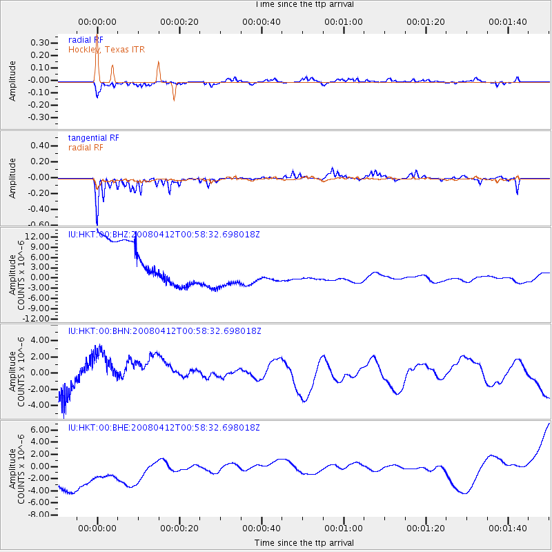
HKT Hockley, Texas - Earthquake Result Viewer
*The percent match for this event was below the threshold and hence no stack was calculated.
| Earthquake location: |
Kuril Islands |
| Earthquake latitude/longitude: |
43.9/147.5 |
| Earthquake time(UTC): |
2008/04/12 (103) 00:46:28 GMT |
| Earthquake Depth: |
64 km |
| Earthquake Magnitude: |
5.7 MB |
| Earthquake Catalog/Contributor: |
WHDF/NEIC |
|
| Network: |
IU Global Seismograph Network (GSN - IRIS/USGS) |
| Station: |
HKT Hockley, Texas |
| Lat/Lon: |
29.96 N/95.84 W |
| Elevation: |
-413.0 m |
|
| Distance: |
86.5 deg |
| Az: |
50.988 deg |
| Baz: |
319.648 deg |
| Ray Param: |
$rayparam |
*The percent match for this event was below the threshold and hence was not used in the summary stack. |
|
| Radial Match: |
58.270065 % |
| Radial Bump: |
334 |
| Transverse Match: |
61.10373 % |
| Transverse Bump: |
246 |
| SOD ConfigId: |
2504 |
| Insert Time: |
2010-03-02 14:01:08.403 +0000 |
| GWidth: |
2.5 |
| Max Bumps: |
400 |
| Tol: |
0.001 |
|
Signal To Noise
| Channel | StoN | STA | LTA |
| IU:HKT:00:BHN:20080412T00:58:32.698018Z | 0.09767842 | 1.5177413E-6 | 1.5538144E-5 |
| IU:HKT:00:BHE:20080412T00:58:32.698018Z | 0.8886797 | 7.929267E-6 | 8.922525E-6 |
| IU:HKT:00:BHZ:20080412T00:58:32.698018Z | 1.0921829 | 6.4331666E-6 | 5.890192E-6 |
| Arrivals |
| Ps | |
| PpPs | |
| PsPs/PpSs | |


