You are here: Home > Network List > AZ - ANZA Regional Network Stations List
> Station SMER AZ.SMER > Earthquake Result Viewer
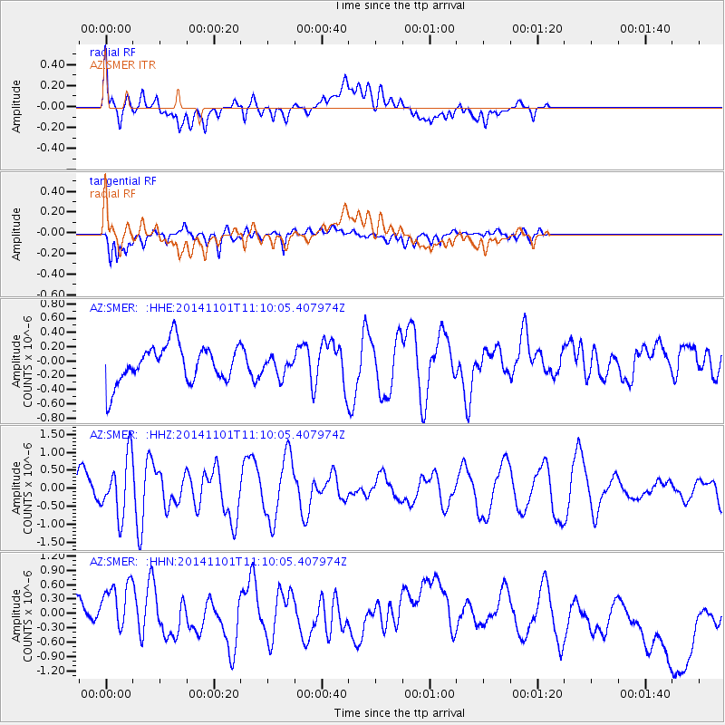
SMER AZ.SMER - Earthquake Result Viewer
*The percent match for this event was below the threshold and hence no stack was calculated.
| Earthquake location: |
Easter Island Region |
| Earthquake latitude/longitude: |
-31.8/-111.2 |
| Earthquake time(UTC): |
2014/11/01 (305) 10:59:55 GMT |
| Earthquake Depth: |
10 km |
| Earthquake Magnitude: |
6.0 MWP |
| Earthquake Catalog/Contributor: |
NEIC PDE/NEIC COMCAT |
|
| Network: |
AZ ANZA Regional Network |
| Station: |
SMER AZ.SMER |
| Lat/Lon: |
33.46 N/117.17 W |
| Elevation: |
355 m |
|
| Distance: |
65.2 deg |
| Az: |
354.483 deg |
| Baz: |
174.382 deg |
| Ray Param: |
$rayparam |
*The percent match for this event was below the threshold and hence was not used in the summary stack. |
|
| Radial Match: |
37.13517 % |
| Radial Bump: |
400 |
| Transverse Match: |
46.53796 % |
| Transverse Bump: |
400 |
| SOD ConfigId: |
813215 |
| Insert Time: |
2014-11-15 11:10:04.011 +0000 |
| GWidth: |
2.5 |
| Max Bumps: |
400 |
| Tol: |
0.001 |
|
Signal To Noise
| Channel | StoN | STA | LTA |
| AZ:SMER: :HHZ:20141101T11:10:05.407974Z | 3.376036 | 8.083112E-7 | 2.3942613E-7 |
| AZ:SMER: :HHN:20141101T11:10:05.407974Z | 1.8816974 | 8.4143943E-7 | 4.4717044E-7 |
| AZ:SMER: :HHE:20141101T11:10:05.407974Z | 0.47217974 | 1.2416326E-7 | 2.6295763E-7 |
| Arrivals |
| Ps | |
| PpPs | |
| PsPs/PpSs | |


