You are here: Home > Network List > IU - Global Seismograph Network (GSN - IRIS/USGS) Stations List
> Station HKT Hockley, Texas > Earthquake Result Viewer
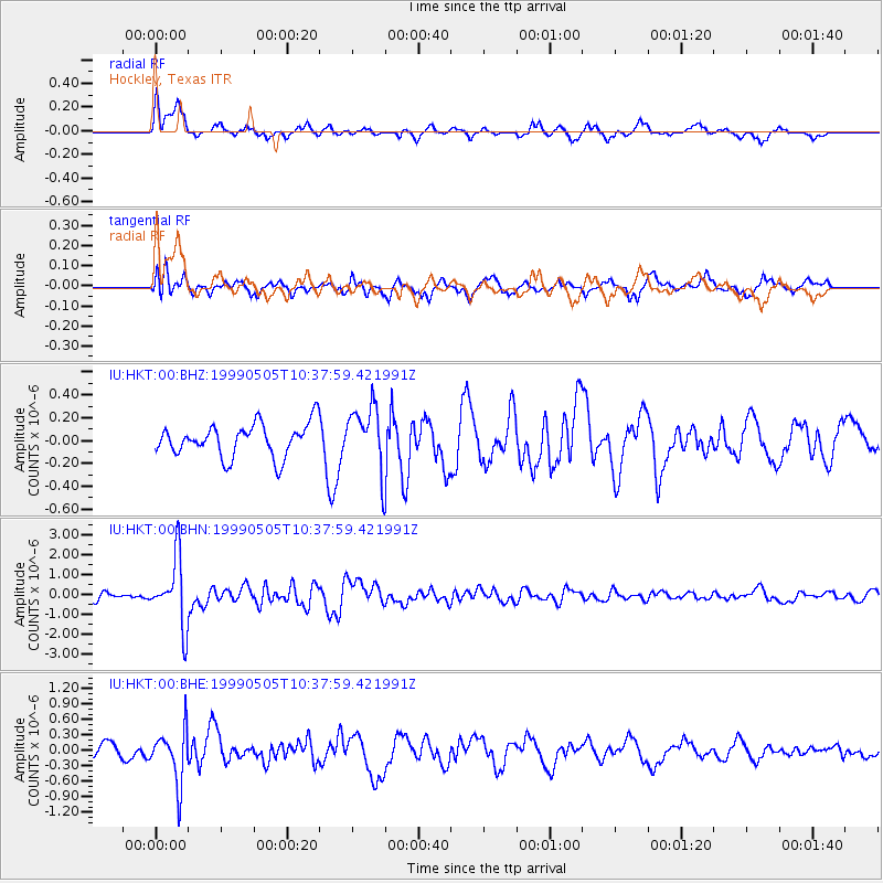
HKT Hockley, Texas - Earthquake Result Viewer
*The percent match for this event was below the threshold and hence no stack was calculated.
| Earthquake location: |
Kenai Peninsula, Alaska |
| Earthquake latitude/longitude: |
59.3/-151.5 |
| Earthquake time(UTC): |
1999/05/05 (125) 10:30:03 GMT |
| Earthquake Depth: |
71 km |
| Earthquake Magnitude: |
5.4 MB, 5.8 MW, 5.8 MW |
| Earthquake Catalog/Contributor: |
WHDF/NEIC |
|
| Network: |
IU Global Seismograph Network (GSN - IRIS/USGS) |
| Station: |
HKT Hockley, Texas |
| Lat/Lon: |
29.96 N/95.84 W |
| Elevation: |
-413.0 m |
|
| Distance: |
47.3 deg |
| Az: |
102.953 deg |
| Baz: |
324.806 deg |
| Ray Param: |
$rayparam |
*The percent match for this event was below the threshold and hence was not used in the summary stack. |
|
| Radial Match: |
64.10864 % |
| Radial Bump: |
284 |
| Transverse Match: |
55.40717 % |
| Transverse Bump: |
400 |
| SOD ConfigId: |
4480 |
| Insert Time: |
2010-03-02 14:01:23.779 +0000 |
| GWidth: |
2.5 |
| Max Bumps: |
400 |
| Tol: |
0.001 |
|
Signal To Noise
| Channel | StoN | STA | LTA |
| IU:HKT:00:BHN:19990505T10:37:59.421991Z | 10.624845 | 1.714058E-6 | 1.6132547E-7 |
| IU:HKT:00:BHE:19990505T10:37:59.421991Z | 2.9110937 | 5.1386644E-7 | 1.7652006E-7 |
| IU:HKT:00:BHZ:19990505T10:37:59.421991Z | 1.9390527 | 2.763365E-7 | 1.4251107E-7 |
| Arrivals |
| Ps | |
| PpPs | |
| PsPs/PpSs | |


