You are here: Home > Network List > CM - Red Sismologica Nacional de Columbia Stations List
> Station URI Uribia, Guajira, Columbia > Earthquake Result Viewer
URI Uribia, Guajira, Columbia - Earthquake Result Viewer
| Earthquake location: |
Easter Island Region |
| Earthquake latitude/longitude: |
-31.8/-111.2 |
| Earthquake time(UTC): |
2014/11/01 (305) 10:59:55 GMT |
| Earthquake Depth: |
10 km |
| Earthquake Magnitude: |
6.0 MWP |
| Earthquake Catalog/Contributor: |
NEIC PDE/NEIC COMCAT |
|
| Network: |
CM Red Sismologica Nacional de Columbia |
| Station: |
URI Uribia, Guajira, Columbia |
| Lat/Lon: |
11.70 N/71.99 W |
| Elevation: |
68 m |
|
| Distance: |
57.3 deg |
| Az: |
47.363 deg |
| Baz: |
219.744 deg |
| Ray Param: |
0.063590944 |
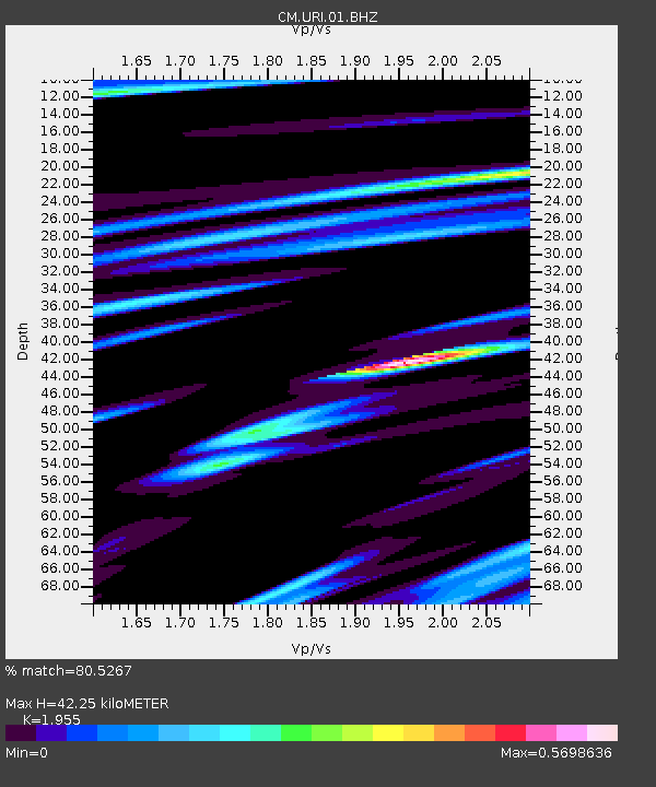
| Estimated Moho Depth: |
42.25 km |
| Estimated Crust Vp/Vs: |
1.96 |
| Assumed Crust Vp: |
5.738 km/s |
| Estimated Crust Vs: |
2.935 km/s |
| Estimated Crust Poisson's Ratio: |
0.32 |
|
| Radial Match: |
80.5267 % |
| Radial Bump: |
400 |
| Transverse Match: |
59.773235 % |
| Transverse Bump: |
400 |
| SOD ConfigId: |
813215 |
| Insert Time: |
2014-11-15 11:13:45.159 +0000 |
| GWidth: |
2.5 |
| Max Bumps: |
400 |
| Tol: |
0.001 |
|

Signal To Noise
| Channel | StoN | STA | LTA |
| CM:URI:01:BHZ:20141101T11:09:12.032974Z | 7.8064785 | 1.307473E-6 | 1.6748564E-7 |
| CM:URI:01:BHN:20141101T11:09:12.032974Z | 2.4953032 | 4.666135E-7 | 1.8699672E-7 |
| CM:URI:01:BHE:20141101T11:09:12.032974Z | 1.382615 | 4.660609E-7 | 3.3708656E-7 |
| Arrivals |
| Ps | 7.3 SECOND |
| PpPs | 21 SECOND |
| PsPs/PpSs | 28 SECOND |


