You are here: Home > Network List > IU - Global Seismograph Network (GSN - IRIS/USGS) Stations List
> Station HKT Hockley, Texas > Earthquake Result Viewer
HKT Hockley, Texas - Earthquake Result Viewer
*The percent match for this event was below the threshold and hence no stack was calculated.
| Earthquake location: |
Kuril Islands |
| Earthquake latitude/longitude: |
44.7/146.2 |
| Earthquake time(UTC): |
1997/10/22 (295) 09:55:47 GMT |
| Earthquake Depth: |
154 km |
| Earthquake Magnitude: |
5.5 MB, 5.6 UNKNOWN, 5.6 MW |
| Earthquake Catalog/Contributor: |
WHDF/NEIC |
|
| Network: |
IU Global Seismograph Network (GSN - IRIS/USGS) |
| Station: |
HKT Hockley, Texas |
| Lat/Lon: |
29.96 N/95.84 W |
| Elevation: |
-413.0 m |
|
| Distance: |
86.6 deg |
| Az: |
50.165 deg |
| Baz: |
320.888 deg |
| Ray Param: |
$rayparam |
*The percent match for this event was below the threshold and hence was not used in the summary stack. |
|
| Radial Match: |
49.387764 % |
| Radial Bump: |
378 |
| Transverse Match: |
62.456226 % |
| Transverse Bump: |
400 |
| SOD ConfigId: |
4480 |
| Insert Time: |
2010-03-02 14:01:33.825 +0000 |
| GWidth: |
2.5 |
| Max Bumps: |
400 |
| Tol: |
0.001 |
|
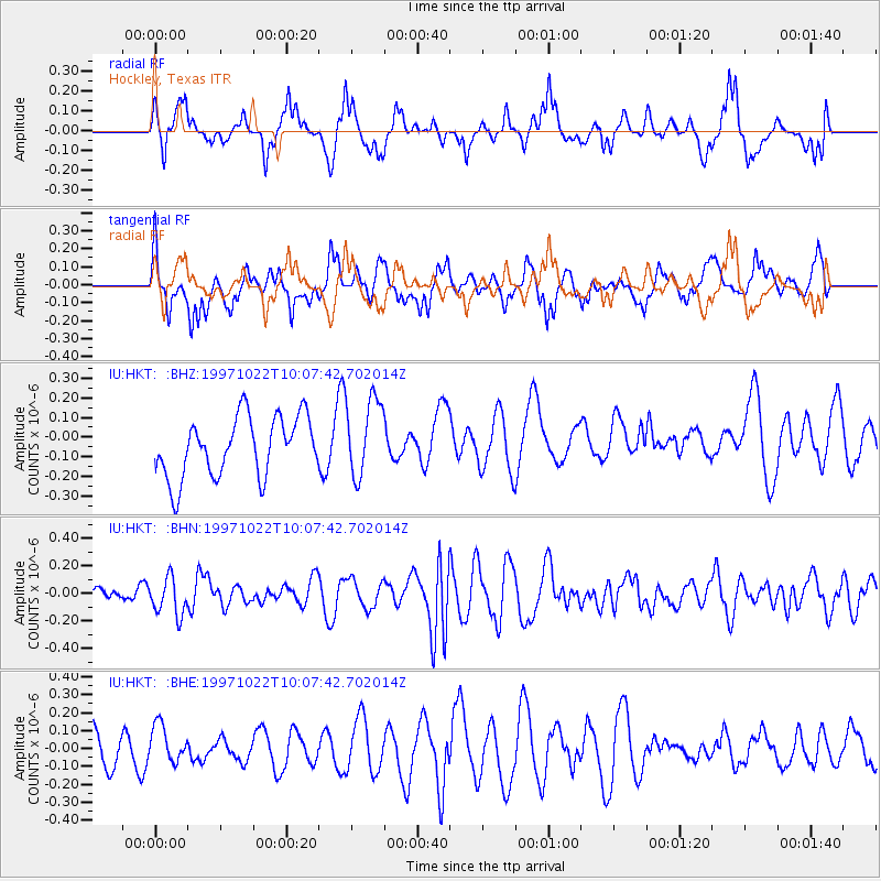
Signal To Noise
| Channel | StoN | STA | LTA |
| IU:HKT: :BHN:19971022T10:07:42.702014Z | 2.097154 | 1.3484646E-7 | 6.429974E-8 |
| IU:HKT: :BHE:19971022T10:07:42.702014Z | 1.0098643 | 1.0044367E-7 | 9.946253E-8 |
| IU:HKT: :BHZ:19971022T10:07:42.702014Z | 1.3225731 | 2.032545E-7 | 1.536811E-7 |
| Arrivals |
| Ps | |
| PpPs | |
| PsPs/PpSs | |


