You are here: Home > Network List > G - GEOSCOPE Stations List
> Station MPG Montagne des Peres, French Guyana > Earthquake Result Viewer
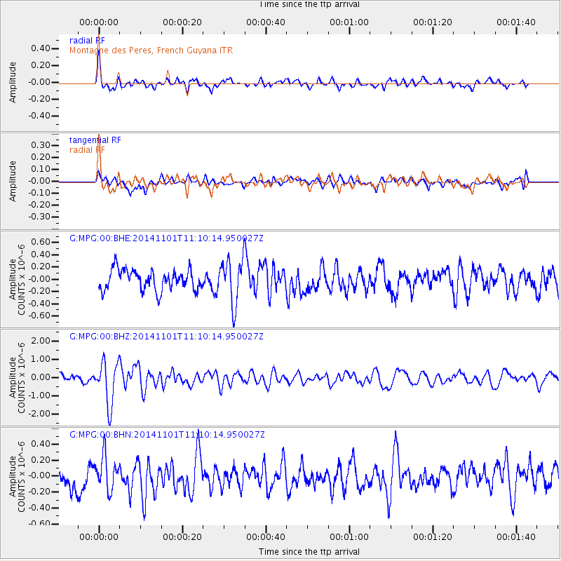
MPG Montagne des Peres, French Guyana - Earthquake Result Viewer
*The percent match for this event was below the threshold and hence no stack was calculated.
| Earthquake location: |
Easter Island Region |
| Earthquake latitude/longitude: |
-31.8/-111.2 |
| Earthquake time(UTC): |
2014/11/01 (305) 10:59:55 GMT |
| Earthquake Depth: |
10 km |
| Earthquake Magnitude: |
6.0 MWP |
| Earthquake Catalog/Contributor: |
NEIC PDE/NEIC COMCAT |
|
| Network: |
G GEOSCOPE |
| Station: |
MPG Montagne des Peres, French Guyana |
| Lat/Lon: |
5.11 N/52.64 W |
| Elevation: |
147 m |
|
| Distance: |
66.7 deg |
| Az: |
67.718 deg |
| Baz: |
232.261 deg |
| Ray Param: |
$rayparam |
*The percent match for this event was below the threshold and hence was not used in the summary stack. |
|
| Radial Match: |
70.36996 % |
| Radial Bump: |
400 |
| Transverse Match: |
54.870373 % |
| Transverse Bump: |
400 |
| SOD ConfigId: |
813215 |
| Insert Time: |
2014-11-15 11:16:28.054 +0000 |
| GWidth: |
2.5 |
| Max Bumps: |
400 |
| Tol: |
0.001 |
|
Signal To Noise
| Channel | StoN | STA | LTA |
| G:MPG:00:BHZ:20141101T11:10:14.950027Z | 7.572257 | 1.2075598E-6 | 1.5947157E-7 |
| G:MPG:00:BHN:20141101T11:10:14.950027Z | 1.697338 | 2.1101206E-7 | 1.2431941E-7 |
| G:MPG:00:BHE:20141101T11:10:14.950027Z | 2.3197074 | 3.8081038E-7 | 1.6416311E-7 |
| Arrivals |
| Ps | |
| PpPs | |
| PsPs/PpSs | |


