You are here: Home > Network List > MX - Mexican National Seismic Network Stations List
> Station MOIG Morelia, Mich, MX > Earthquake Result Viewer
MOIG Morelia, Mich, MX - Earthquake Result Viewer
| Earthquake location: |
Easter Island Region |
| Earthquake latitude/longitude: |
-31.8/-111.2 |
| Earthquake time(UTC): |
2014/11/01 (305) 10:59:55 GMT |
| Earthquake Depth: |
10 km |
| Earthquake Magnitude: |
6.0 MWP |
| Earthquake Catalog/Contributor: |
NEIC PDE/NEIC COMCAT |
|
| Network: |
MX Mexican National Seismic Network |
| Station: |
MOIG Morelia, Mich, MX |
| Lat/Lon: |
19.65 N/101.23 W |
| Elevation: |
2000 m |
|
| Distance: |
52.1 deg |
| Az: |
11.92 deg |
| Baz: |
190.752 deg |
| Ray Param: |
0.06700435 |
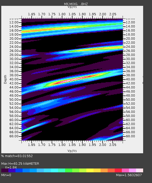
| Estimated Moho Depth: |
40.25 km |
| Estimated Crust Vp/Vs: |
1.84 |
| Assumed Crust Vp: |
6.566 km/s |
| Estimated Crust Vs: |
3.569 km/s |
| Estimated Crust Poisson's Ratio: |
0.29 |
|
| Radial Match: |
83.01552 % |
| Radial Bump: |
400 |
| Transverse Match: |
85.33587 % |
| Transverse Bump: |
400 |
| SOD ConfigId: |
813215 |
| Insert Time: |
2014-11-15 11:21:13.321 +0000 |
| GWidth: |
2.5 |
| Max Bumps: |
400 |
| Tol: |
0.001 |
|

Signal To Noise
| Channel | StoN | STA | LTA |
| MX:MOIG: :BHZ:20141101T11:08:34.211013Z | 8.560353 | 1.7325741E-6 | 2.0239517E-7 |
| MX:MOIG: :BHN:20141101T11:08:34.211013Z | 2.3589952 | 7.024662E-7 | 2.9778195E-7 |
| MX:MOIG: :BHE:20141101T11:08:34.211013Z | 1.7593833 | 4.221304E-7 | 2.399309E-7 |
| Arrivals |
| Ps | 5.4 SECOND |
| PpPs | 16 SECOND |
| PsPs/PpSs | 22 SECOND |


