You are here: Home > Network List > CB - China National Seismic Network Stations List
> Station DL2 Dalian,Liaoning Province > Earthquake Result Viewer
DL2 Dalian,Liaoning Province - Earthquake Result Viewer
| Earthquake location: |
Northern Sumatra, Indonesia |
| Earthquake latitude/longitude: |
1.5/97.9 |
| Earthquake time(UTC): |
2015/05/08 (128) 03:12:20 GMT |
| Earthquake Depth: |
34 km |
| Earthquake Magnitude: |
5.9 MB |
| Earthquake Catalog/Contributor: |
NEIC PDE/NEIC COMCAT |
|
| Network: |
CB China National Seismic Network |
| Station: |
DL2 Dalian,Liaoning Province |
| Lat/Lon: |
38.91 N/121.63 E |
| Elevation: |
65 m |
|
| Distance: |
43.1 deg |
| Az: |
27.414 deg |
| Baz: |
216.149 deg |
| Ray Param: |
0.07272165 |
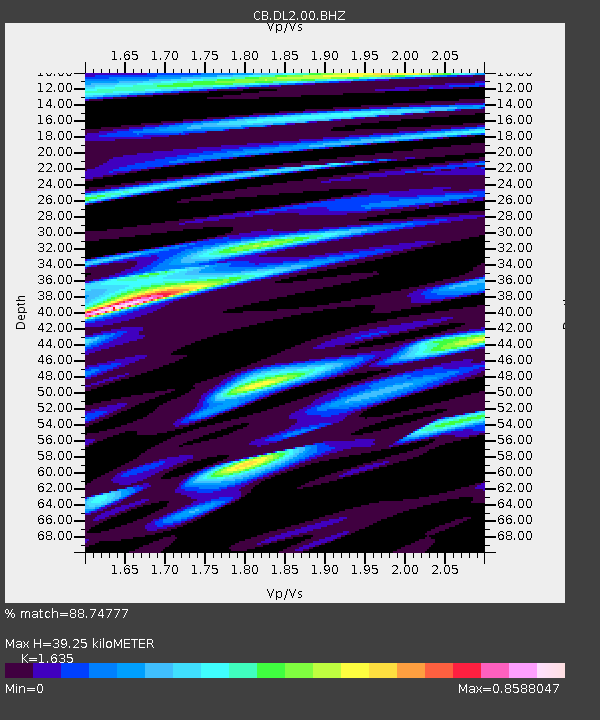
| Estimated Moho Depth: |
39.25 km |
| Estimated Crust Vp/Vs: |
1.63 |
| Assumed Crust Vp: |
6.134 km/s |
| Estimated Crust Vs: |
3.752 km/s |
| Estimated Crust Poisson's Ratio: |
0.20 |
|
| Radial Match: |
88.74777 % |
| Radial Bump: |
400 |
| Transverse Match: |
78.54078 % |
| Transverse Bump: |
400 |
| SOD ConfigId: |
7422571 |
| Insert Time: |
2019-04-18 18:10:00.130 +0000 |
| GWidth: |
2.5 |
| Max Bumps: |
400 |
| Tol: |
0.001 |
|

Signal To Noise
| Channel | StoN | STA | LTA |
| CB:DL2:00:BHZ:20150508T03:19:45.919993Z | 11.977583 | 1.7021754E-6 | 1.4211342E-7 |
| CB:DL2:00:BHN:20150508T03:19:45.919993Z | 6.736909 | 8.149566E-7 | 1.2096892E-7 |
| CB:DL2:00:BHE:20150508T03:19:45.919993Z | 5.001098 | 5.473873E-7 | 1.0945341E-7 |
| Arrivals |
| Ps | 4.3 SECOND |
| PpPs | 16 SECOND |
| PsPs/PpSs | 20 SECOND |


