You are here: Home > Network List > KN - Kyrgyz Seismic Telemetry Network Stations List
> Station KBK KN.KBK > Earthquake Result Viewer
KBK KN.KBK - Earthquake Result Viewer
| Earthquake location: |
Northern Sumatra, Indonesia |
| Earthquake latitude/longitude: |
1.5/97.9 |
| Earthquake time(UTC): |
2015/05/08 (128) 03:12:20 GMT |
| Earthquake Depth: |
34 km |
| Earthquake Magnitude: |
5.9 MB |
| Earthquake Catalog/Contributor: |
NEIC PDE/NEIC COMCAT |
|
| Network: |
KN Kyrgyz Seismic Telemetry Network |
| Station: |
KBK KN.KBK |
| Lat/Lon: |
42.66 N/74.95 E |
| Elevation: |
1760 m |
|
| Distance: |
45.8 deg |
| Az: |
336.371 deg |
| Baz: |
147.103 deg |
| Ray Param: |
0.07097925 |
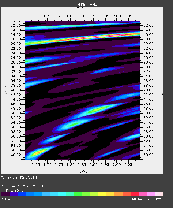
| Estimated Moho Depth: |
16.75 km |
| Estimated Crust Vp/Vs: |
1.91 |
| Assumed Crust Vp: |
6.306 km/s |
| Estimated Crust Vs: |
3.306 km/s |
| Estimated Crust Poisson's Ratio: |
0.31 |
|
| Radial Match: |
92.15614 % |
| Radial Bump: |
357 |
| Transverse Match: |
88.1663 % |
| Transverse Bump: |
400 |
| SOD ConfigId: |
7422571 |
| Insert Time: |
2019-04-18 18:10:55.409 +0000 |
| GWidth: |
2.5 |
| Max Bumps: |
400 |
| Tol: |
0.001 |
|
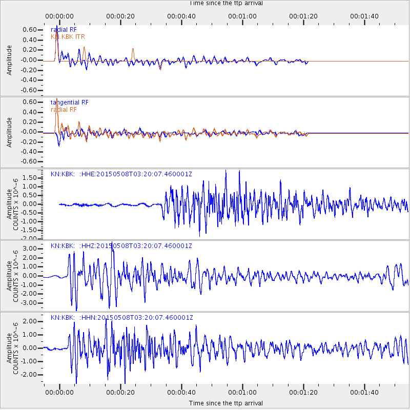
Signal To Noise
| Channel | StoN | STA | LTA |
| KN:KBK: :HHZ:20150508T03:20:07.460001Z | 26.65436 | 1.274355E-6 | 4.7810374E-8 |
| KN:KBK: :HHN:20150508T03:20:07.460001Z | 13.911123 | 6.9496855E-7 | 4.995776E-8 |
| KN:KBK: :HHE:20150508T03:20:07.460001Z | 7.600925 | 3.0784352E-7 | 4.0500794E-8 |
| Arrivals |
| Ps | 2.5 SECOND |
| PpPs | 7.3 SECOND |
| PsPs/PpSs | 9.9 SECOND |


