You are here: Home > Network List > TJ - Tajikistan National Seismic Network Stations List
> Station MANEM Manem, Tajikistan > Earthquake Result Viewer
MANEM Manem, Tajikistan - Earthquake Result Viewer
| Earthquake location: |
Northern Sumatra, Indonesia |
| Earthquake latitude/longitude: |
1.5/97.9 |
| Earthquake time(UTC): |
2015/05/08 (128) 03:12:20 GMT |
| Earthquake Depth: |
34 km |
| Earthquake Magnitude: |
5.9 MB |
| Earthquake Catalog/Contributor: |
NEIC PDE/NEIC COMCAT |
|
| Network: |
TJ Tajikistan National Seismic Network |
| Station: |
MANEM Manem, Tajikistan |
| Lat/Lon: |
37.53 N/71.66 E |
| Elevation: |
2312 m |
|
| Distance: |
43.2 deg |
| Az: |
329.127 deg |
| Baz: |
139.818 deg |
| Ray Param: |
0.072650455 |
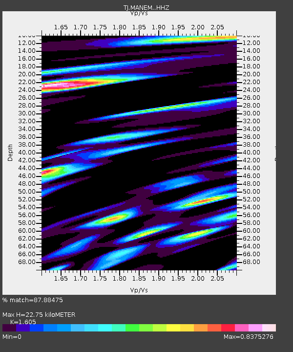
| Estimated Moho Depth: |
22.75 km |
| Estimated Crust Vp/Vs: |
1.61 |
| Assumed Crust Vp: |
6.306 km/s |
| Estimated Crust Vs: |
3.929 km/s |
| Estimated Crust Poisson's Ratio: |
0.18 |
|
| Radial Match: |
87.88475 % |
| Radial Bump: |
400 |
| Transverse Match: |
88.73137 % |
| Transverse Bump: |
400 |
| SOD ConfigId: |
7422571 |
| Insert Time: |
2019-04-18 18:11:38.237 +0000 |
| GWidth: |
2.5 |
| Max Bumps: |
400 |
| Tol: |
0.001 |
|

Signal To Noise
| Channel | StoN | STA | LTA |
| TJ:MANEM: :HHZ:20150508T03:19:46.590006Z | 10.354826 | 2.2202446E-6 | 2.1441642E-7 |
| TJ:MANEM: :HHN:20150508T03:19:46.590006Z | 10.246158 | 8.8135397E-7 | 8.6018E-8 |
| TJ:MANEM: :HHE:20150508T03:19:46.590006Z | 7.812214 | 7.55806E-7 | 9.674671E-8 |
| Arrivals |
| Ps | 2.3 SECOND |
| PpPs | 8.8 SECOND |
| PsPs/PpSs | 11 SECOND |


