You are here: Home > Network List > YB13 - Continental Dynamics/Cent. Anatolian Tectonics:Surface to Mantle Dynamics During Stations List
> Station AT16 Ekinozu,Maras,Turkey > Earthquake Result Viewer
AT16 Ekinozu,Maras,Turkey - Earthquake Result Viewer
| Earthquake location: |
Northern Sumatra, Indonesia |
| Earthquake latitude/longitude: |
1.5/97.9 |
| Earthquake time(UTC): |
2015/05/08 (128) 03:12:20 GMT |
| Earthquake Depth: |
34 km |
| Earthquake Magnitude: |
5.9 MB |
| Earthquake Catalog/Contributor: |
NEIC PDE/NEIC COMCAT |
|
| Network: |
YB Continental Dynamics/Cent. Anatolian Tectonics:Surface to Mantle Dynamics During |
| Station: |
AT16 Ekinozu,Maras,Turkey |
| Lat/Lon: |
38.08 N/37.14 E |
| Elevation: |
1279 m |
|
| Distance: |
66.3 deg |
| Az: |
311.25 deg |
| Baz: |
107.745 deg |
| Ray Param: |
0.057658497 |
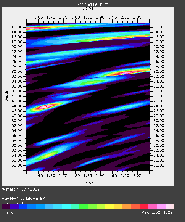
| Estimated Moho Depth: |
44.0 km |
| Estimated Crust Vp/Vs: |
1.68 |
| Assumed Crust Vp: |
6.35 km/s |
| Estimated Crust Vs: |
3.78 km/s |
| Estimated Crust Poisson's Ratio: |
0.23 |
|
| Radial Match: |
87.41859 % |
| Radial Bump: |
400 |
| Transverse Match: |
77.44271 % |
| Transverse Bump: |
400 |
| SOD ConfigId: |
7422571 |
| Insert Time: |
2019-04-18 18:12:20.476 +0000 |
| GWidth: |
2.5 |
| Max Bumps: |
400 |
| Tol: |
0.001 |
|

Signal To Noise
| Channel | StoN | STA | LTA |
| YB:AT16: :BHZ:20150508T03:22:33.47999Z | 8.644007 | 3.5111142E-7 | 4.061906E-8 |
| YB:AT16: :BHN:20150508T03:22:33.47999Z | 3.398043 | 1.3507629E-7 | 3.97512E-8 |
| YB:AT16: :BHE:20150508T03:22:33.47999Z | 5.9044456 | 1.2771248E-7 | 2.1629885E-8 |
| Arrivals |
| Ps | 4.9 SECOND |
| PpPs | 18 SECOND |
| PsPs/PpSs | 23 SECOND |


