You are here: Home > Network List > YB13 - Continental Dynamics/Cent. Anatolian Tectonics:Surface to Mantle Dynamics During Stations List
> Station AT21 Asiklar,Nevsehir,Turkey > Earthquake Result Viewer
AT21 Asiklar,Nevsehir,Turkey - Earthquake Result Viewer
| Earthquake location: |
Northern Sumatra, Indonesia |
| Earthquake latitude/longitude: |
1.5/97.9 |
| Earthquake time(UTC): |
2015/05/08 (128) 03:12:20 GMT |
| Earthquake Depth: |
34 km |
| Earthquake Magnitude: |
5.9 MB |
| Earthquake Catalog/Contributor: |
NEIC PDE/NEIC COMCAT |
|
| Network: |
YB Continental Dynamics/Cent. Anatolian Tectonics:Surface to Mantle Dynamics During |
| Station: |
AT21 Asiklar,Nevsehir,Turkey |
| Lat/Lon: |
38.93 N/34.52 E |
| Elevation: |
1279 m |
|
| Distance: |
68.5 deg |
| Az: |
311.474 deg |
| Baz: |
106.211 deg |
| Ray Param: |
0.056213316 |
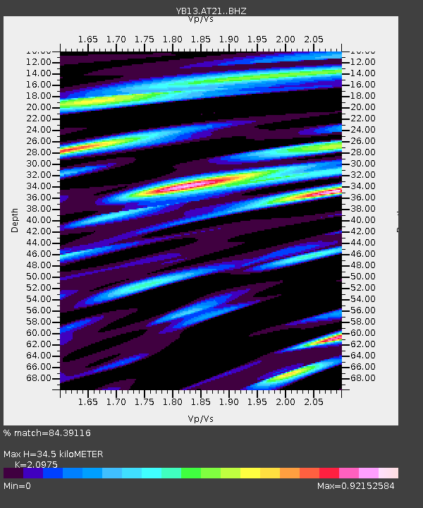
| Estimated Moho Depth: |
34.5 km |
| Estimated Crust Vp/Vs: |
2.10 |
| Assumed Crust Vp: |
6.35 km/s |
| Estimated Crust Vs: |
3.027 km/s |
| Estimated Crust Poisson's Ratio: |
0.35 |
|
| Radial Match: |
84.39116 % |
| Radial Bump: |
400 |
| Transverse Match: |
78.799904 % |
| Transverse Bump: |
400 |
| SOD ConfigId: |
7422571 |
| Insert Time: |
2019-04-18 18:12:23.701 +0000 |
| GWidth: |
2.5 |
| Max Bumps: |
400 |
| Tol: |
0.001 |
|

Signal To Noise
| Channel | StoN | STA | LTA |
| YB:AT21: :BHZ:20150508T03:22:47.380015Z | 9.56604 | 5.572479E-7 | 5.825273E-8 |
| YB:AT21: :BHN:20150508T03:22:47.380015Z | 2.5089555 | 1.4909166E-7 | 5.9423794E-8 |
| YB:AT21: :BHE:20150508T03:22:47.380015Z | 7.1339865 | 2.4760178E-7 | 3.470735E-8 |
| Arrivals |
| Ps | 6.2 SECOND |
| PpPs | 16 SECOND |
| PsPs/PpSs | 22 SECOND |


