You are here: Home > Network List > PB - Plate Boundary Observatory Borehole Seismic Network Stations List
> Station B087 fordra087bcs2006, Anza, CA, USA > Earthquake Result Viewer
B087 fordra087bcs2006, Anza, CA, USA - Earthquake Result Viewer
| Earthquake location: |
Easter Island Region |
| Earthquake latitude/longitude: |
-31.8/-111.2 |
| Earthquake time(UTC): |
2014/11/01 (305) 10:59:55 GMT |
| Earthquake Depth: |
10 km |
| Earthquake Magnitude: |
6.0 MWP |
| Earthquake Catalog/Contributor: |
NEIC PDE/NEIC COMCAT |
|
| Network: |
PB Plate Boundary Observatory Borehole Seismic Network |
| Station: |
B087 fordra087bcs2006, Anza, CA, USA |
| Lat/Lon: |
33.50 N/116.60 W |
| Elevation: |
1139 m |
|
| Distance: |
65.2 deg |
| Az: |
355.008 deg |
| Baz: |
174.914 deg |
| Ray Param: |
0.058447804 |
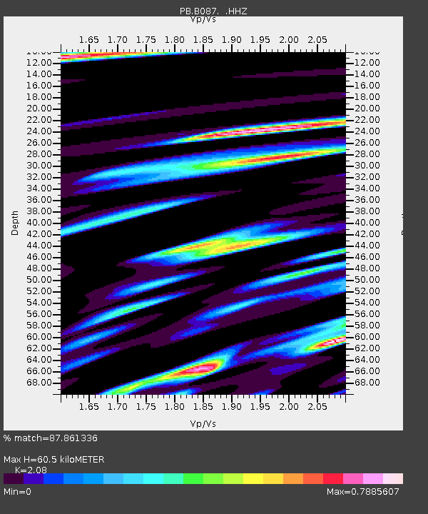
| Estimated Moho Depth: |
60.5 km |
| Estimated Crust Vp/Vs: |
2.08 |
| Assumed Crust Vp: |
6.264 km/s |
| Estimated Crust Vs: |
3.011 km/s |
| Estimated Crust Poisson's Ratio: |
0.35 |
|
| Radial Match: |
87.861336 % |
| Radial Bump: |
400 |
| Transverse Match: |
72.112366 % |
| Transverse Bump: |
400 |
| SOD ConfigId: |
813215 |
| Insert Time: |
2014-11-15 11:29:35.043 +0000 |
| GWidth: |
2.5 |
| Max Bumps: |
400 |
| Tol: |
0.001 |
|

Signal To Noise
| Channel | StoN | STA | LTA |
| PB:B087: :HHZ:20141101T11:10:05.359023Z | 9.293096 | 3.191012E-8 | 3.4337448E-9 |
| PB:B087: :HH1:20141101T11:10:05.359023Z | 2.7017415 | 9.9666195E-9 | 3.6889611E-9 |
| PB:B087: :HH2:20141101T11:10:05.359023Z | 1.2306203 | 4.5050332E-9 | 3.6607828E-9 |
| Arrivals |
| Ps | 11 SECOND |
| PpPs | 29 SECOND |
| PsPs/PpSs | 40 SECOND |


