You are here: Home > Network List > TA - USArray Transportable Network (new EarthScope stations) Stations List
> Station E62A Clayton Lake, ME, USA > Earthquake Result Viewer
E62A Clayton Lake, ME, USA - Earthquake Result Viewer
*The percent match for this event was below the threshold and hence no stack was calculated.
| Earthquake location: |
Easter Island Region |
| Earthquake latitude/longitude: |
-31.8/-111.2 |
| Earthquake time(UTC): |
2014/11/01 (305) 10:59:55 GMT |
| Earthquake Depth: |
10 km |
| Earthquake Magnitude: |
6.0 MWP |
| Earthquake Catalog/Contributor: |
NEIC PDE/NEIC COMCAT |
|
| Network: |
TA USArray Transportable Network (new EarthScope stations) |
| Station: |
E62A Clayton Lake, ME, USA |
| Lat/Lon: |
46.62 N/69.52 W |
| Elevation: |
356 m |
|
| Distance: |
86.7 deg |
| Az: |
27.317 deg |
| Baz: |
214.525 deg |
| Ray Param: |
$rayparam |
*The percent match for this event was below the threshold and hence was not used in the summary stack. |
|
| Radial Match: |
52.046448 % |
| Radial Bump: |
296 |
| Transverse Match: |
58.72266 % |
| Transverse Bump: |
374 |
| SOD ConfigId: |
813215 |
| Insert Time: |
2014-11-15 11:33:51.109 +0000 |
| GWidth: |
2.5 |
| Max Bumps: |
400 |
| Tol: |
0.001 |
|
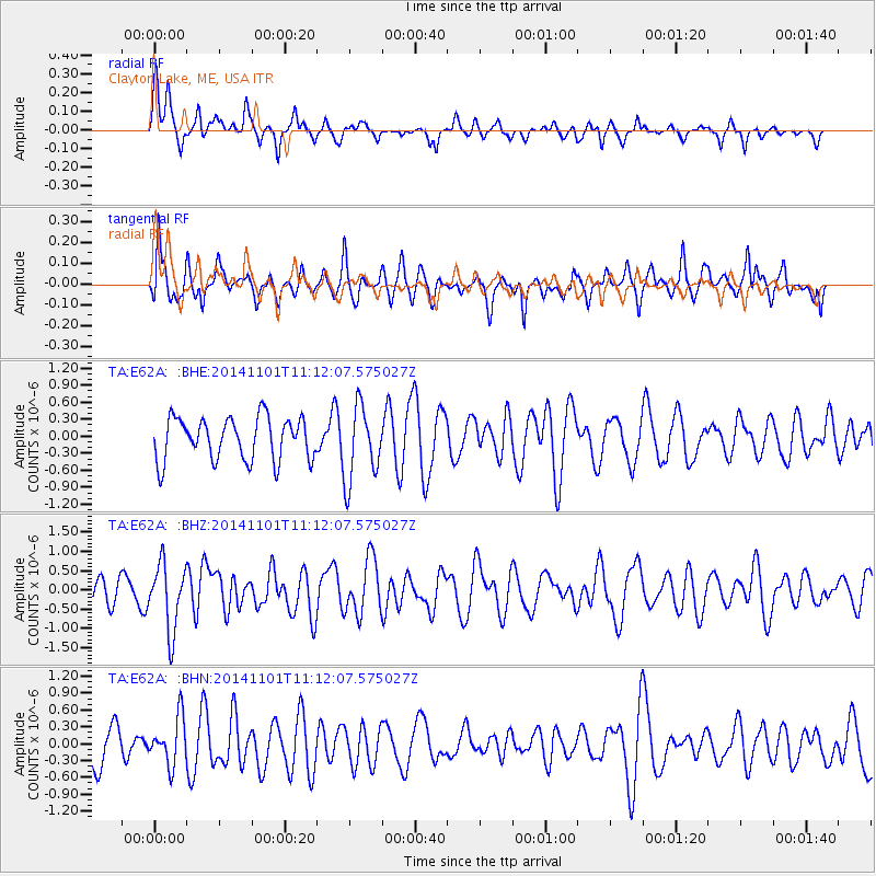
Signal To Noise
| Channel | StoN | STA | LTA |
| TA:E62A: :BHZ:20141101T11:12:07.575027Z | 2.0427864 | 8.623276E-7 | 4.2213304E-7 |
| TA:E62A: :BHN:20141101T11:12:07.575027Z | 1.2410709 | 4.1923917E-7 | 3.3780438E-7 |
| TA:E62A: :BHE:20141101T11:12:07.575027Z | 1.766545 | 6.6180024E-7 | 3.7462974E-7 |
| Arrivals |
| Ps | |
| PpPs | |
| PsPs/PpSs | |


