You are here: Home > Network List > IU - Global Seismograph Network (GSN - IRIS/USGS) Stations List
> Station WCI Wyandotte Cave, Indiana, USA > Earthquake Result Viewer
WCI Wyandotte Cave, Indiana, USA - Earthquake Result Viewer
| Earthquake location: |
Kuril Islands |
| Earthquake latitude/longitude: |
48.8/155.0 |
| Earthquake time(UTC): |
2003/04/24 (114) 10:56:21 GMT |
| Earthquake Depth: |
44 km |
| Earthquake Magnitude: |
5.6 MB, 5.7 MS, 6.1 MW, 6.0 MW |
| Earthquake Catalog/Contributor: |
WHDF/NEIC |
|
| Network: |
IU Global Seismograph Network (GSN - IRIS/USGS) |
| Station: |
WCI Wyandotte Cave, Indiana, USA |
| Lat/Lon: |
38.23 N/86.29 W |
| Elevation: |
638 m |
|
| Distance: |
77.8 deg |
| Az: |
44.969 deg |
| Baz: |
323.577 deg |
| Ray Param: |
0.050016288 |
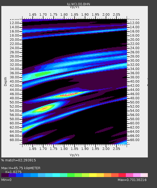
| Estimated Moho Depth: |
45.75 km |
| Estimated Crust Vp/Vs: |
1.83 |
| Assumed Crust Vp: |
6.444 km/s |
| Estimated Crust Vs: |
3.526 km/s |
| Estimated Crust Poisson's Ratio: |
0.29 |
|
| Radial Match: |
82.293915 % |
| Radial Bump: |
304 |
| Transverse Match: |
60.773865 % |
| Transverse Bump: |
400 |
| SOD ConfigId: |
4714 |
| Insert Time: |
2010-03-02 14:02:17.180 +0000 |
| GWidth: |
2.5 |
| Max Bumps: |
400 |
| Tol: |
0.001 |
|

Signal To Noise
| Channel | StoN | STA | LTA |
| IU:WCI:00:BHN:20030424T11:07:43.526997Z | 2.2480843 | 2.1272469E-7 | 9.462487E-8 |
| IU:WCI:00:BHE:20030424T11:07:43.526997Z | 2.8254938 | 1.921925E-7 | 6.802085E-8 |
| IU:WCI:00:BHZ:20030424T11:07:43.526997Z | 5.6681795 | 6.74043E-7 | 1.18917015E-7 |
| Arrivals |
| Ps | 6.1 SECOND |
| PpPs | 19 SECOND |
| PsPs/PpSs | 26 SECOND |


