You are here: Home > Network List > TA - USArray Transportable Network (new EarthScope stations) Stations List
> Station G57A Newington, ON, CAN > Earthquake Result Viewer
G57A Newington, ON, CAN - Earthquake Result Viewer
| Earthquake location: |
Easter Island Region |
| Earthquake latitude/longitude: |
-31.8/-111.2 |
| Earthquake time(UTC): |
2014/11/01 (305) 10:59:55 GMT |
| Earthquake Depth: |
10 km |
| Earthquake Magnitude: |
6.0 MWP |
| Earthquake Catalog/Contributor: |
NEIC PDE/NEIC COMCAT |
|
| Network: |
TA USArray Transportable Network (new EarthScope stations) |
| Station: |
G57A Newington, ON, CAN |
| Lat/Lon: |
45.10 N/74.99 W |
| Elevation: |
96 m |
|
| Distance: |
83.3 deg |
| Az: |
24.901 deg |
| Baz: |
210.405 deg |
| Ray Param: |
0.046261676 |
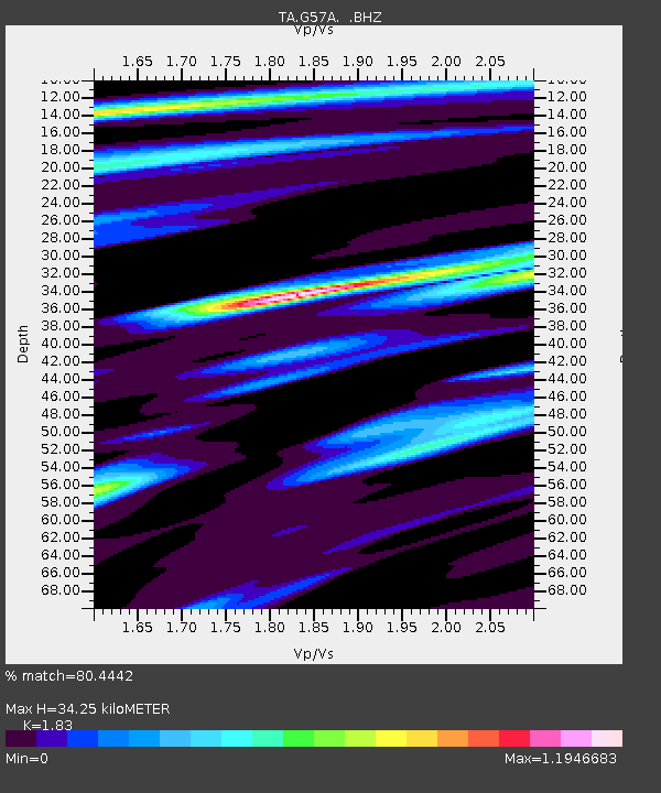
| Estimated Moho Depth: |
34.25 km |
| Estimated Crust Vp/Vs: |
1.83 |
| Assumed Crust Vp: |
6.419 km/s |
| Estimated Crust Vs: |
3.508 km/s |
| Estimated Crust Poisson's Ratio: |
0.29 |
|
| Radial Match: |
80.4442 % |
| Radial Bump: |
400 |
| Transverse Match: |
52.713078 % |
| Transverse Bump: |
362 |
| SOD ConfigId: |
813215 |
| Insert Time: |
2014-11-15 11:34:26.863 +0000 |
| GWidth: |
2.5 |
| Max Bumps: |
400 |
| Tol: |
0.001 |
|
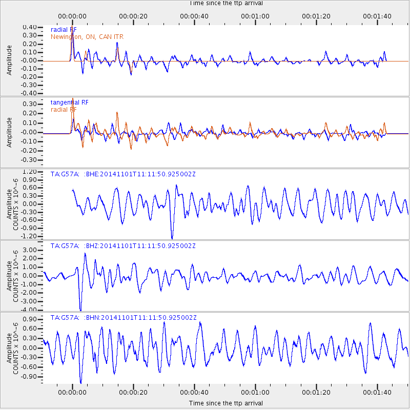
Signal To Noise
| Channel | StoN | STA | LTA |
| TA:G57A: :BHZ:20141101T11:11:50.925002Z | 5.3396797 | 1.6852205E-6 | 3.156033E-7 |
| TA:G57A: :BHN:20141101T11:11:50.925002Z | 2.2029116 | 4.6954122E-7 | 2.1314574E-7 |
| TA:G57A: :BHE:20141101T11:11:50.925002Z | 1.782964 | 5.5632046E-7 | 3.1202E-7 |
| Arrivals |
| Ps | 4.5 SECOND |
| PpPs | 15 SECOND |
| PsPs/PpSs | 19 SECOND |


