You are here: Home > Network List > TA - USArray Transportable Network (new EarthScope stations) Stations List
> Station I61A Oroboro, Fairlee, VT, USA > Earthquake Result Viewer
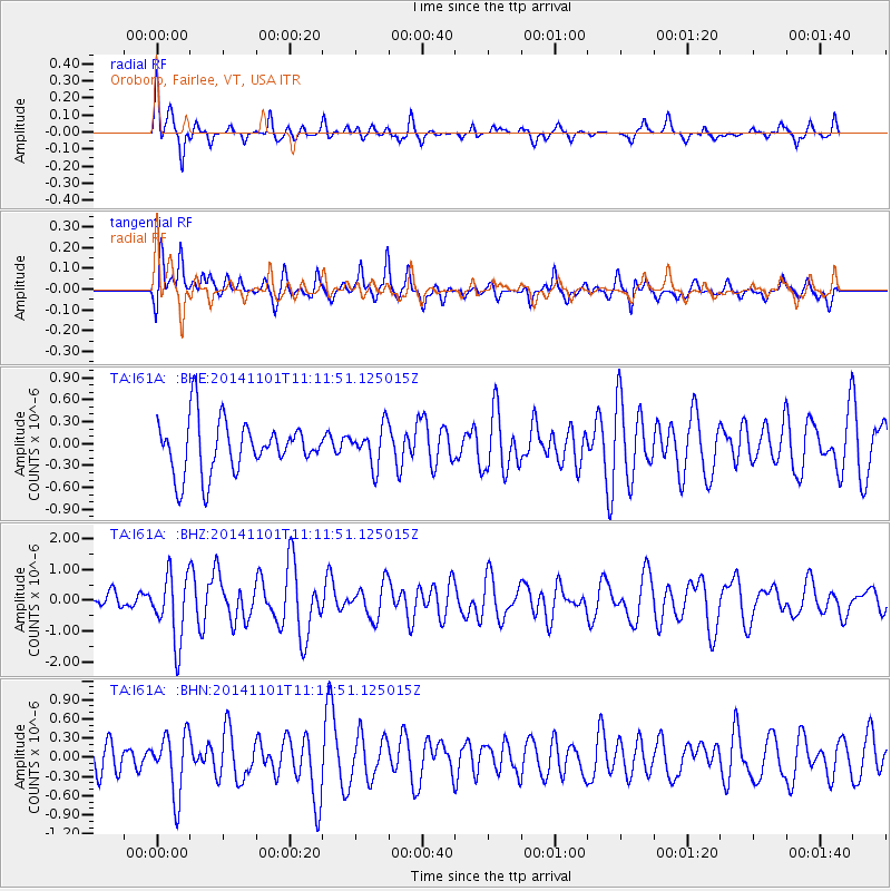
I61A Oroboro, Fairlee, VT, USA - Earthquake Result Viewer
*The percent match for this event was below the threshold and hence no stack was calculated.
| Earthquake location: |
Easter Island Region |
| Earthquake latitude/longitude: |
-31.8/-111.2 |
| Earthquake time(UTC): |
2014/11/01 (305) 10:59:55 GMT |
| Earthquake Depth: |
10 km |
| Earthquake Magnitude: |
6.0 MWP |
| Earthquake Catalog/Contributor: |
NEIC PDE/NEIC COMCAT |
|
| Network: |
TA USArray Transportable Network (new EarthScope stations) |
| Station: |
I61A Oroboro, Fairlee, VT, USA |
| Lat/Lon: |
43.93 N/72.21 W |
| Elevation: |
287 m |
|
| Distance: |
83.4 deg |
| Az: |
27.222 deg |
| Baz: |
212.614 deg |
| Ray Param: |
$rayparam |
*The percent match for this event was below the threshold and hence was not used in the summary stack. |
|
| Radial Match: |
68.25466 % |
| Radial Bump: |
400 |
| Transverse Match: |
76.376625 % |
| Transverse Bump: |
400 |
| SOD ConfigId: |
813215 |
| Insert Time: |
2014-11-15 11:35:52.759 +0000 |
| GWidth: |
2.5 |
| Max Bumps: |
400 |
| Tol: |
0.001 |
|
Signal To Noise
| Channel | StoN | STA | LTA |
| TA:I61A: :BHZ:20141101T11:11:51.125015Z | 2.774636 | 1.07701E-6 | 3.8816262E-7 |
| TA:I61A: :BHN:20141101T11:11:51.125015Z | 1.9320738 | 4.7698387E-7 | 2.4687662E-7 |
| TA:I61A: :BHE:20141101T11:11:51.125015Z | 0.7530437 | 2.6777025E-7 | 3.5558395E-7 |
| Arrivals |
| Ps | |
| PpPs | |
| PsPs/PpSs | |


