You are here: Home > Network List > TA - USArray Transportable Network (new EarthScope stations) Stations List
> Station O03E Paynes Creek, CA, USA > Earthquake Result Viewer
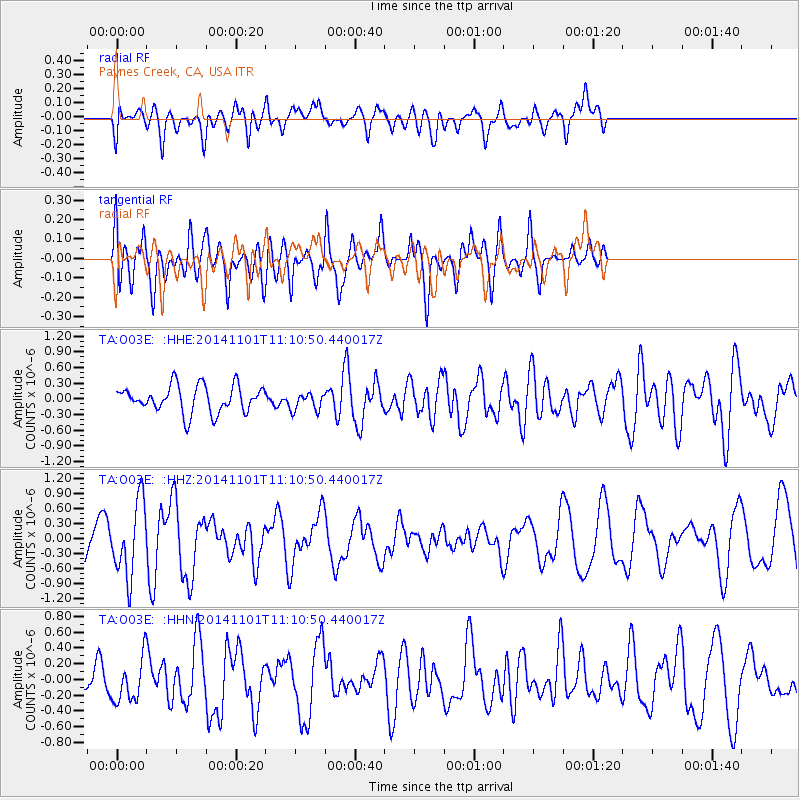
O03E Paynes Creek, CA, USA - Earthquake Result Viewer
*The percent match for this event was below the threshold and hence no stack was calculated.
| Earthquake location: |
Easter Island Region |
| Earthquake latitude/longitude: |
-31.8/-111.2 |
| Earthquake time(UTC): |
2014/11/01 (305) 10:59:55 GMT |
| Earthquake Depth: |
10 km |
| Earthquake Magnitude: |
6.0 MWP |
| Earthquake Catalog/Contributor: |
NEIC PDE/NEIC COMCAT |
|
| Network: |
TA USArray Transportable Network (new EarthScope stations) |
| Station: |
O03E Paynes Creek, CA, USA |
| Lat/Lon: |
40.29 N/121.80 W |
| Elevation: |
967 m |
|
| Distance: |
72.4 deg |
| Az: |
351.495 deg |
| Baz: |
170.526 deg |
| Ray Param: |
$rayparam |
*The percent match for this event was below the threshold and hence was not used in the summary stack. |
|
| Radial Match: |
65.9376 % |
| Radial Bump: |
400 |
| Transverse Match: |
63.195934 % |
| Transverse Bump: |
400 |
| SOD ConfigId: |
813215 |
| Insert Time: |
2014-11-15 11:38:21.565 +0000 |
| GWidth: |
2.5 |
| Max Bumps: |
400 |
| Tol: |
0.001 |
|
Signal To Noise
| Channel | StoN | STA | LTA |
| TA:O03E: :HHZ:20141101T11:10:50.440017Z | 2.6724248 | 7.3557374E-7 | 2.752458E-7 |
| TA:O03E: :HHN:20141101T11:10:50.440017Z | 1.317401 | 2.6285235E-7 | 1.9952343E-7 |
| TA:O03E: :HHE:20141101T11:10:50.440017Z | 0.6909743 | 1.7722809E-7 | 2.5649013E-7 |
| Arrivals |
| Ps | |
| PpPs | |
| PsPs/PpSs | |


