You are here: Home > Network List > TA - USArray Transportable Network (new EarthScope stations) Stations List
> Station P54A Burton, WV, USA > Earthquake Result Viewer
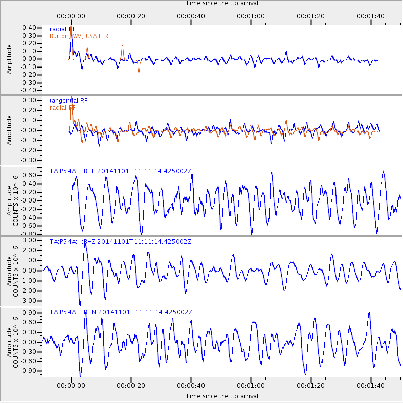
P54A Burton, WV, USA - Earthquake Result Viewer
*The percent match for this event was below the threshold and hence no stack was calculated.
| Earthquake location: |
Easter Island Region |
| Earthquake latitude/longitude: |
-31.8/-111.2 |
| Earthquake time(UTC): |
2014/11/01 (305) 10:59:55 GMT |
| Earthquake Depth: |
10 km |
| Earthquake Magnitude: |
6.0 MWP |
| Earthquake Catalog/Contributor: |
NEIC PDE/NEIC COMCAT |
|
| Network: |
TA USArray Transportable Network (new EarthScope stations) |
| Station: |
P54A Burton, WV, USA |
| Lat/Lon: |
39.61 N/80.48 W |
| Elevation: |
473 m |
|
| Distance: |
76.6 deg |
| Az: |
23.922 deg |
| Baz: |
206.54 deg |
| Ray Param: |
$rayparam |
*The percent match for this event was below the threshold and hence was not used in the summary stack. |
|
| Radial Match: |
64.51317 % |
| Radial Bump: |
400 |
| Transverse Match: |
68.08748 % |
| Transverse Bump: |
400 |
| SOD ConfigId: |
813215 |
| Insert Time: |
2014-11-15 11:38:54.232 +0000 |
| GWidth: |
2.5 |
| Max Bumps: |
400 |
| Tol: |
0.001 |
|
Signal To Noise
| Channel | StoN | STA | LTA |
| TA:P54A: :BHZ:20141101T11:11:14.425002Z | 2.963465 | 1.5158835E-6 | 5.1152404E-7 |
| TA:P54A: :BHN:20141101T11:11:14.425002Z | 1.7711035 | 4.79404E-7 | 2.7068097E-7 |
| TA:P54A: :BHE:20141101T11:11:14.425002Z | 0.55683297 | 2.0861737E-7 | 3.7464977E-7 |
| Arrivals |
| Ps | |
| PpPs | |
| PsPs/PpSs | |


