You are here: Home > Network List > TA - USArray Transportable Network (new EarthScope stations) Stations List
> Station Q54A Coxs Mills, WV, USA > Earthquake Result Viewer
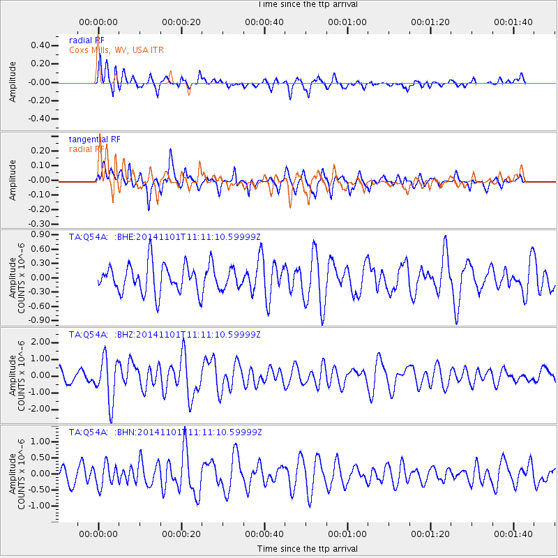
Q54A Coxs Mills, WV, USA - Earthquake Result Viewer
*The percent match for this event was below the threshold and hence no stack was calculated.
| Earthquake location: |
Easter Island Region |
| Earthquake latitude/longitude: |
-31.8/-111.2 |
| Earthquake time(UTC): |
2014/11/01 (305) 10:59:55 GMT |
| Earthquake Depth: |
10 km |
| Earthquake Magnitude: |
6.0 MWP |
| Earthquake Catalog/Contributor: |
NEIC PDE/NEIC COMCAT |
|
| Network: |
TA USArray Transportable Network (new EarthScope stations) |
| Station: |
Q54A Coxs Mills, WV, USA |
| Lat/Lon: |
38.98 N/80.83 W |
| Elevation: |
254 m |
|
| Distance: |
75.9 deg |
| Az: |
23.954 deg |
| Baz: |
206.325 deg |
| Ray Param: |
$rayparam |
*The percent match for this event was below the threshold and hence was not used in the summary stack. |
|
| Radial Match: |
57.45247 % |
| Radial Bump: |
400 |
| Transverse Match: |
59.6277 % |
| Transverse Bump: |
383 |
| SOD ConfigId: |
813215 |
| Insert Time: |
2014-11-15 11:39:20.841 +0000 |
| GWidth: |
2.5 |
| Max Bumps: |
400 |
| Tol: |
0.001 |
|
Signal To Noise
| Channel | StoN | STA | LTA |
| TA:Q54A: :BHZ:20141101T11:11:10.59999Z | 3.1077158 | 1.3322467E-6 | 4.2869002E-7 |
| TA:Q54A: :BHN:20141101T11:11:10.59999Z | 1.0561565 | 3.4493536E-7 | 3.2659491E-7 |
| TA:Q54A: :BHE:20141101T11:11:10.59999Z | 0.644841 | 1.9115335E-7 | 2.9643485E-7 |
| Arrivals |
| Ps | |
| PpPs | |
| PsPs/PpSs | |


