You are here: Home > Network List > TA - USArray Transportable Network (new EarthScope stations) Stations List
> Station Q56A Snyder Ridge, Maysville, WV, USA > Earthquake Result Viewer
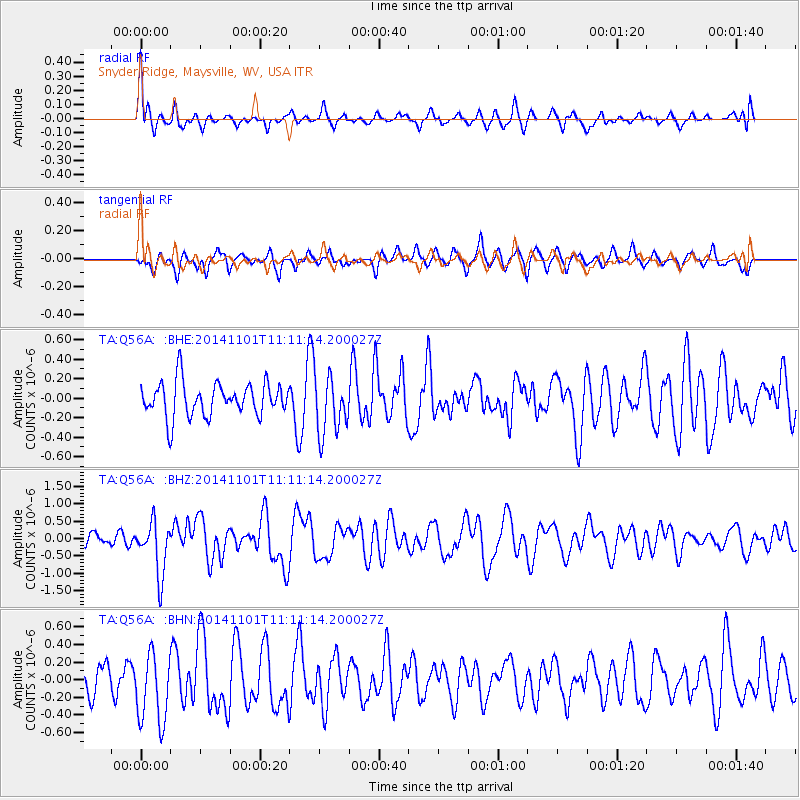
Q56A Snyder Ridge, Maysville, WV, USA - Earthquake Result Viewer
*The percent match for this event was below the threshold and hence no stack was calculated.
| Earthquake location: |
Easter Island Region |
| Earthquake latitude/longitude: |
-31.8/-111.2 |
| Earthquake time(UTC): |
2014/11/01 (305) 10:59:55 GMT |
| Earthquake Depth: |
10 km |
| Earthquake Magnitude: |
6.0 MWP |
| Earthquake Catalog/Contributor: |
NEIC PDE/NEIC COMCAT |
|
| Network: |
TA USArray Transportable Network (new EarthScope stations) |
| Station: |
Q56A Snyder Ridge, Maysville, WV, USA |
| Lat/Lon: |
39.04 N/79.19 W |
| Elevation: |
430 m |
|
| Distance: |
76.5 deg |
| Az: |
25.105 deg |
| Baz: |
207.631 deg |
| Ray Param: |
$rayparam |
*The percent match for this event was below the threshold and hence was not used in the summary stack. |
|
| Radial Match: |
58.097794 % |
| Radial Bump: |
400 |
| Transverse Match: |
52.810024 % |
| Transverse Bump: |
400 |
| SOD ConfigId: |
813215 |
| Insert Time: |
2014-11-15 11:39:25.654 +0000 |
| GWidth: |
2.5 |
| Max Bumps: |
400 |
| Tol: |
0.001 |
|
Signal To Noise
| Channel | StoN | STA | LTA |
| TA:Q56A: :BHZ:20141101T11:11:14.200027Z | 3.2281554 | 7.5705134E-7 | 2.3451514E-7 |
| TA:Q56A: :BHN:20141101T11:11:14.200027Z | 2.2861967 | 4.0278803E-7 | 1.7618257E-7 |
| TA:Q56A: :BHE:20141101T11:11:14.200027Z | 1.7640338 | 3.0583382E-7 | 1.7337184E-7 |
| Arrivals |
| Ps | |
| PpPs | |
| PsPs/PpSs | |


