You are here: Home > Network List > TA - USArray Transportable Network (new EarthScope stations) Stations List
> Station R59A King George, VA, USA > Earthquake Result Viewer
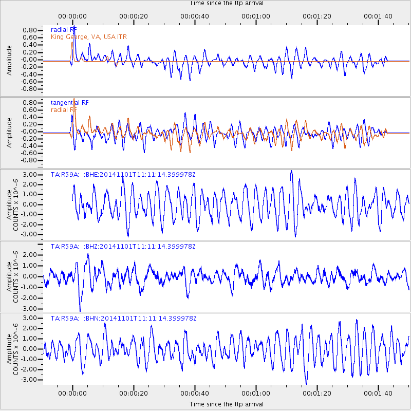
R59A King George, VA, USA - Earthquake Result Viewer
*The percent match for this event was below the threshold and hence no stack was calculated.
| Earthquake location: |
Easter Island Region |
| Earthquake latitude/longitude: |
-31.8/-111.2 |
| Earthquake time(UTC): |
2014/11/01 (305) 10:59:55 GMT |
| Earthquake Depth: |
10 km |
| Earthquake Magnitude: |
6.0 MWP |
| Earthquake Catalog/Contributor: |
NEIC PDE/NEIC COMCAT |
|
| Network: |
TA USArray Transportable Network (new EarthScope stations) |
| Station: |
R59A King George, VA, USA |
| Lat/Lon: |
38.20 N/77.12 W |
| Elevation: |
35 m |
|
| Distance: |
76.6 deg |
| Az: |
26.983 deg |
| Baz: |
209.356 deg |
| Ray Param: |
$rayparam |
*The percent match for this event was below the threshold and hence was not used in the summary stack. |
|
| Radial Match: |
64.5834 % |
| Radial Bump: |
400 |
| Transverse Match: |
54.173164 % |
| Transverse Bump: |
400 |
| SOD ConfigId: |
813215 |
| Insert Time: |
2014-11-15 11:40:01.508 +0000 |
| GWidth: |
2.5 |
| Max Bumps: |
400 |
| Tol: |
0.001 |
|
Signal To Noise
| Channel | StoN | STA | LTA |
| TA:R59A: :BHZ:20141101T11:11:14.399978Z | 3.460206 | 1.3252867E-6 | 3.8300803E-7 |
| TA:R59A: :BHN:20141101T11:11:14.399978Z | 1.1215402 | 1.2077335E-6 | 1.0768526E-6 |
| TA:R59A: :BHE:20141101T11:11:14.399978Z | 1.2675042 | 1.4664848E-6 | 1.1569862E-6 |
| Arrivals |
| Ps | |
| PpPs | |
| PsPs/PpSs | |


