You are here: Home > Network List > TA - USArray Transportable Network (new EarthScope stations) Stations List
> Station S55A Lewisburg, WV, USA > Earthquake Result Viewer
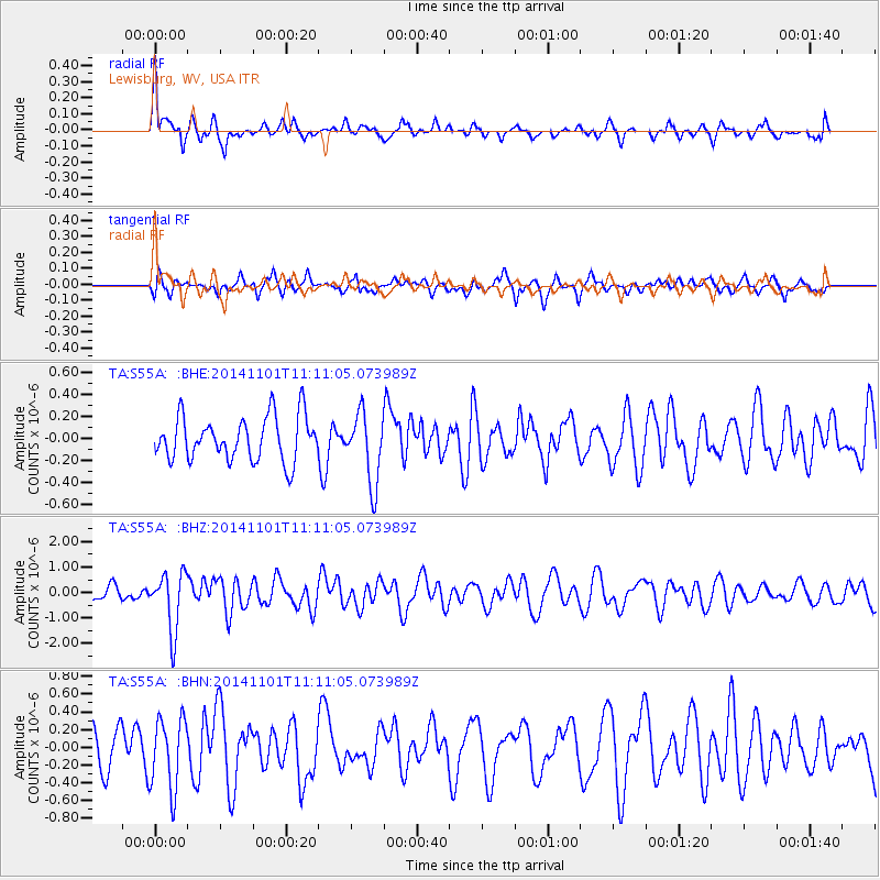
S55A Lewisburg, WV, USA - Earthquake Result Viewer
*The percent match for this event was below the threshold and hence no stack was calculated.
| Earthquake location: |
Easter Island Region |
| Earthquake latitude/longitude: |
-31.8/-111.2 |
| Earthquake time(UTC): |
2014/11/01 (305) 10:59:55 GMT |
| Earthquake Depth: |
10 km |
| Earthquake Magnitude: |
6.0 MWP |
| Earthquake Catalog/Contributor: |
NEIC PDE/NEIC COMCAT |
|
| Network: |
TA USArray Transportable Network (new EarthScope stations) |
| Station: |
S55A Lewisburg, WV, USA |
| Lat/Lon: |
37.77 N/80.50 W |
| Elevation: |
647 m |
|
| Distance: |
74.9 deg |
| Az: |
24.754 deg |
| Baz: |
206.732 deg |
| Ray Param: |
$rayparam |
*The percent match for this event was below the threshold and hence was not used in the summary stack. |
|
| Radial Match: |
65.41208 % |
| Radial Bump: |
400 |
| Transverse Match: |
56.21439 % |
| Transverse Bump: |
400 |
| SOD ConfigId: |
813215 |
| Insert Time: |
2014-11-15 11:40:14.638 +0000 |
| GWidth: |
2.5 |
| Max Bumps: |
400 |
| Tol: |
0.001 |
|
Signal To Noise
| Channel | StoN | STA | LTA |
| TA:S55A: :BHZ:20141101T11:11:05.073989Z | 4.3234944 | 1.1448292E-6 | 2.6479256E-7 |
| TA:S55A: :BHN:20141101T11:11:05.073989Z | 1.7821652 | 3.9866438E-7 | 2.2369666E-7 |
| TA:S55A: :BHE:20141101T11:11:05.073989Z | 1.5977933 | 3.1485482E-7 | 1.9705602E-7 |
| Arrivals |
| Ps | |
| PpPs | |
| PsPs/PpSs | |


