You are here: Home > Network List > TA - USArray Transportable Network (new EarthScope stations) Stations List
> Station W41B Gary Mavity, Velonia, AR, USA > Earthquake Result Viewer
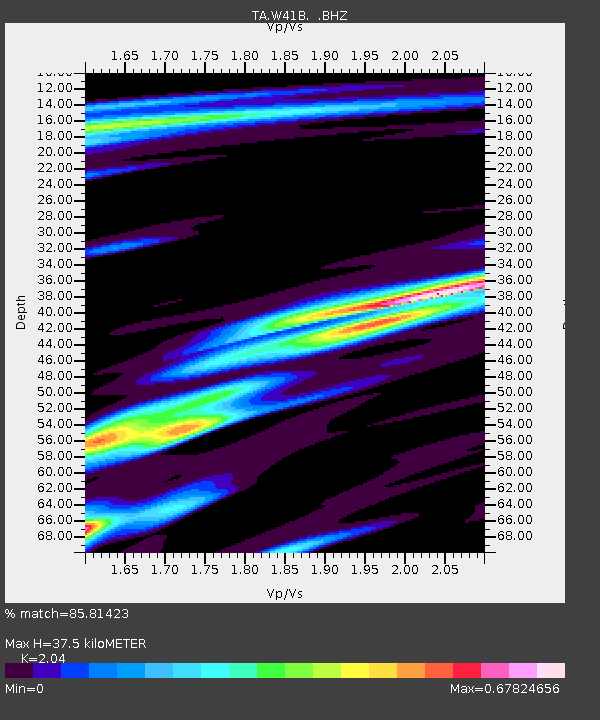
W41B Gary Mavity, Velonia, AR, USA - Earthquake Result Viewer
| Earthquake location: |
Easter Island Region |
| Earthquake latitude/longitude: |
-31.8/-111.2 |
| Earthquake time(UTC): |
2014/11/01 (305) 10:59:55 GMT |
| Earthquake Depth: |
10 km |
| Earthquake Magnitude: |
6.0 MWP |
| Earthquake Catalog/Contributor: |
NEIC PDE/NEIC COMCAT |
|
| Network: |
TA USArray Transportable Network (new EarthScope stations) |
| Station: |
W41B Gary Mavity, Velonia, AR, USA |
| Lat/Lon: |
35.17 N/92.25 W |
| Elevation: |
95 m |
|
| Distance: |
69.0 deg |
| Az: |
16.544 deg |
| Baz: |
197.21 deg |
| Ray Param: |
0.055950936 |
| Estimated Moho Depth: |
37.5 km |
| Estimated Crust Vp/Vs: |
2.04 |
| Assumed Crust Vp: |
6.498 km/s |
| Estimated Crust Vs: |
3.185 km/s |
| Estimated Crust Poisson's Ratio: |
0.34 |
|
| Radial Match: |
85.81423 % |
| Radial Bump: |
332 |
| Transverse Match: |
75.17069 % |
| Transverse Bump: |
400 |
| SOD ConfigId: |
813215 |
| Insert Time: |
2014-11-15 11:41:47.114 +0000 |
| GWidth: |
2.5 |
| Max Bumps: |
400 |
| Tol: |
0.001 |
|

Signal To Noise
| Channel | StoN | STA | LTA |
| TA:W41B: :BHZ:20141101T11:10:29.500015Z | 5.226544 | 1.8857668E-6 | 3.6080567E-7 |
| TA:W41B: :BHN:20141101T11:10:29.500015Z | 3.1087031 | 6.761358E-7 | 2.1749771E-7 |
| TA:W41B: :BHE:20141101T11:10:29.500015Z | 0.7530032 | 1.8424008E-7 | 2.446737E-7 |
| Arrivals |
| Ps | 6.2 SECOND |
| PpPs | 17 SECOND |
| PsPs/PpSs | 23 SECOND |


