You are here: Home > Network List > TA - USArray Transportable Network (new EarthScope stations) Stations List
> Station W57A Gilead, NC, USA > Earthquake Result Viewer
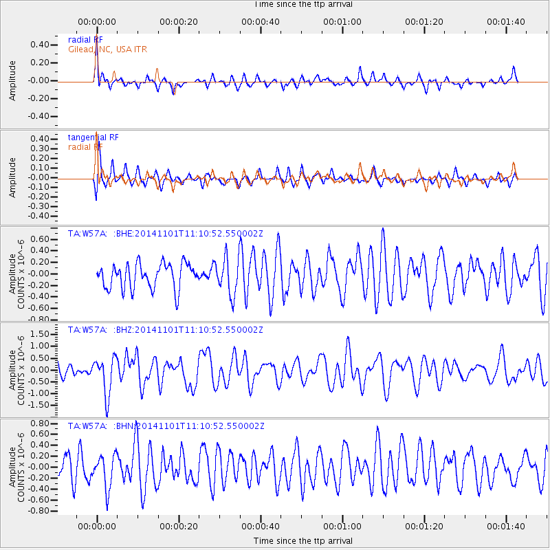
W57A Gilead, NC, USA - Earthquake Result Viewer
*The percent match for this event was below the threshold and hence no stack was calculated.
| Earthquake location: |
Easter Island Region |
| Earthquake latitude/longitude: |
-31.8/-111.2 |
| Earthquake time(UTC): |
2014/11/01 (305) 10:59:55 GMT |
| Earthquake Depth: |
10 km |
| Earthquake Magnitude: |
6.0 MWP |
| Earthquake Catalog/Contributor: |
NEIC PDE/NEIC COMCAT |
|
| Network: |
TA USArray Transportable Network (new EarthScope stations) |
| Station: |
W57A Gilead, NC, USA |
| Lat/Lon: |
35.15 N/79.99 W |
| Elevation: |
85 m |
|
| Distance: |
72.8 deg |
| Az: |
26.374 deg |
| Baz: |
207.483 deg |
| Ray Param: |
$rayparam |
*The percent match for this event was below the threshold and hence was not used in the summary stack. |
|
| Radial Match: |
62.988503 % |
| Radial Bump: |
400 |
| Transverse Match: |
62.66776 % |
| Transverse Bump: |
400 |
| SOD ConfigId: |
813215 |
| Insert Time: |
2014-11-15 11:41:52.979 +0000 |
| GWidth: |
2.5 |
| Max Bumps: |
400 |
| Tol: |
0.001 |
|
Signal To Noise
| Channel | StoN | STA | LTA |
| TA:W57A: :BHZ:20141101T11:10:52.550002Z | 3.796314 | 8.1514656E-7 | 2.1472053E-7 |
| TA:W57A: :BHN:20141101T11:10:52.550002Z | 1.2763432 | 3.142607E-7 | 2.4621957E-7 |
| TA:W57A: :BHE:20141101T11:10:52.550002Z | 1.518973 | 3.2568417E-7 | 2.1441078E-7 |
| Arrivals |
| Ps | |
| PpPs | |
| PsPs/PpSs | |


