You are here: Home > Network List > US - United States National Seismic Network Stations List
> Station CBKS Cedar Bluff, Kansas, USA > Earthquake Result Viewer
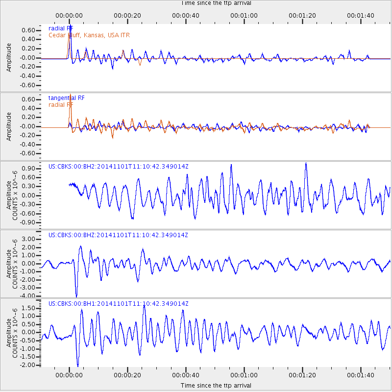
CBKS Cedar Bluff, Kansas, USA - Earthquake Result Viewer
*The percent match for this event was below the threshold and hence no stack was calculated.
| Earthquake location: |
Easter Island Region |
| Earthquake latitude/longitude: |
-31.8/-111.2 |
| Earthquake time(UTC): |
2014/11/01 (305) 10:59:55 GMT |
| Earthquake Depth: |
10 km |
| Earthquake Magnitude: |
6.0 MWP |
| Earthquake Catalog/Contributor: |
NEIC PDE/NEIC COMCAT |
|
| Network: |
US United States National Seismic Network |
| Station: |
CBKS Cedar Bluff, Kansas, USA |
| Lat/Lon: |
38.81 N/99.74 W |
| Elevation: |
677 m |
|
| Distance: |
71.1 deg |
| Az: |
9.429 deg |
| Baz: |
190.284 deg |
| Ray Param: |
$rayparam |
*The percent match for this event was below the threshold and hence was not used in the summary stack. |
|
| Radial Match: |
78.73334 % |
| Radial Bump: |
308 |
| Transverse Match: |
55.367935 % |
| Transverse Bump: |
400 |
| SOD ConfigId: |
813215 |
| Insert Time: |
2014-11-15 11:43:29.730 +0000 |
| GWidth: |
2.5 |
| Max Bumps: |
400 |
| Tol: |
0.001 |
|
Signal To Noise
| Channel | StoN | STA | LTA |
| US:CBKS:00:BHZ:20141101T11:10:42.349014Z | 6.2136006 | 1.6091319E-6 | 2.5896932E-7 |
| US:CBKS:00:BH1:20141101T11:10:42.349014Z | 3.068534 | 9.177809E-7 | 2.9909427E-7 |
| US:CBKS:00:BH2:20141101T11:10:42.349014Z | 1.1454117 | 3.5267144E-7 | 3.0789928E-7 |
| Arrivals |
| Ps | |
| PpPs | |
| PsPs/PpSs | |


