You are here: Home > Network List > US - United States National Seismic Network Stations List
> Station WMOK Wichita Mountains, Oklahoma, USA > Earthquake Result Viewer
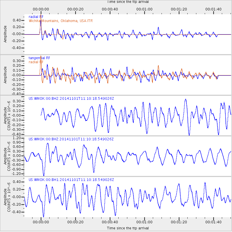
WMOK Wichita Mountains, Oklahoma, USA - Earthquake Result Viewer
*The percent match for this event was below the threshold and hence no stack was calculated.
| Earthquake location: |
Easter Island Region |
| Earthquake latitude/longitude: |
-31.8/-111.2 |
| Earthquake time(UTC): |
2014/11/01 (305) 10:59:55 GMT |
| Earthquake Depth: |
10 km |
| Earthquake Magnitude: |
6.0 MWP |
| Earthquake Catalog/Contributor: |
NEIC PDE/NEIC COMCAT |
|
| Network: |
US United States National Seismic Network |
| Station: |
WMOK Wichita Mountains, Oklahoma, USA |
| Lat/Lon: |
34.74 N/98.78 W |
| Elevation: |
486 m |
|
| Distance: |
67.2 deg |
| Az: |
11.056 deg |
| Baz: |
191.433 deg |
| Ray Param: |
$rayparam |
*The percent match for this event was below the threshold and hence was not used in the summary stack. |
|
| Radial Match: |
64.81758 % |
| Radial Bump: |
400 |
| Transverse Match: |
70.083824 % |
| Transverse Bump: |
400 |
| SOD ConfigId: |
813215 |
| Insert Time: |
2014-11-15 11:45:24.804 +0000 |
| GWidth: |
2.5 |
| Max Bumps: |
400 |
| Tol: |
0.001 |
|
Signal To Noise
| Channel | StoN | STA | LTA |
| US:WMOK:00:BHZ:20141101T11:10:18.549026Z | 3.759073 | 6.7985917E-7 | 1.8085821E-7 |
| US:WMOK:00:BH1:20141101T11:10:18.549026Z | 1.309842 | 2.4743068E-7 | 1.8890117E-7 |
| US:WMOK:00:BH2:20141101T11:10:18.549026Z | 2.0448122 | 1.9476286E-7 | 9.524731E-8 |
| Arrivals |
| Ps | |
| PpPs | |
| PsPs/PpSs | |


