You are here: Home > Network List > AU - Australian Seismological Centre Stations List
> Station BLDU Ballidu, Western Australia > Earthquake Result Viewer
BLDU Ballidu, Western Australia - Earthquake Result Viewer
| Earthquake location: |
Fiji Islands Region |
| Earthquake latitude/longitude: |
-19.7/-177.7 |
| Earthquake time(UTC): |
2014/11/01 (305) 18:57:22 GMT |
| Earthquake Depth: |
434 km |
| Earthquake Magnitude: |
7.1 MWW, 6.9 MI, 7.1 MWC, 7.2 MWB |
| Earthquake Catalog/Contributor: |
NEIC PDE/NEIC COMCAT |
|
| Network: |
AU Australian Seismological Centre |
| Station: |
BLDU Ballidu, Western Australia |
| Lat/Lon: |
30.61 S/116.71 E |
| Elevation: |
280 m |
|
| Distance: |
59.6 deg |
| Az: |
245.484 deg |
| Baz: |
96.076 deg |
| Ray Param: |
0.06047532 |
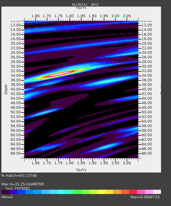
| Estimated Moho Depth: |
33.25 km |
| Estimated Crust Vp/Vs: |
1.75 |
| Assumed Crust Vp: |
6.419 km/s |
| Estimated Crust Vs: |
3.673 km/s |
| Estimated Crust Poisson's Ratio: |
0.26 |
|
| Radial Match: |
93.13746 % |
| Radial Bump: |
331 |
| Transverse Match: |
75.57049 % |
| Transverse Bump: |
400 |
| SOD ConfigId: |
813215 |
| Insert Time: |
2014-11-15 19:09:35.715 +0000 |
| GWidth: |
2.5 |
| Max Bumps: |
400 |
| Tol: |
0.001 |
|

Signal To Noise
| Channel | StoN | STA | LTA |
| AU:BLDU: :BHZ:20141101T19:06:12.069021Z | 21.82406 | 7.42844E-6 | 3.4037848E-7 |
| AU:BLDU: :BHN:20141101T19:06:12.069021Z | 4.2924404 | 7.314746E-7 | 1.7040995E-7 |
| AU:BLDU: :BHE:20141101T19:06:12.069021Z | 14.442359 | 3.8363137E-6 | 2.656293E-7 |
| Arrivals |
| Ps | 4.1 SECOND |
| PpPs | 14 SECOND |
| PsPs/PpSs | 18 SECOND |


