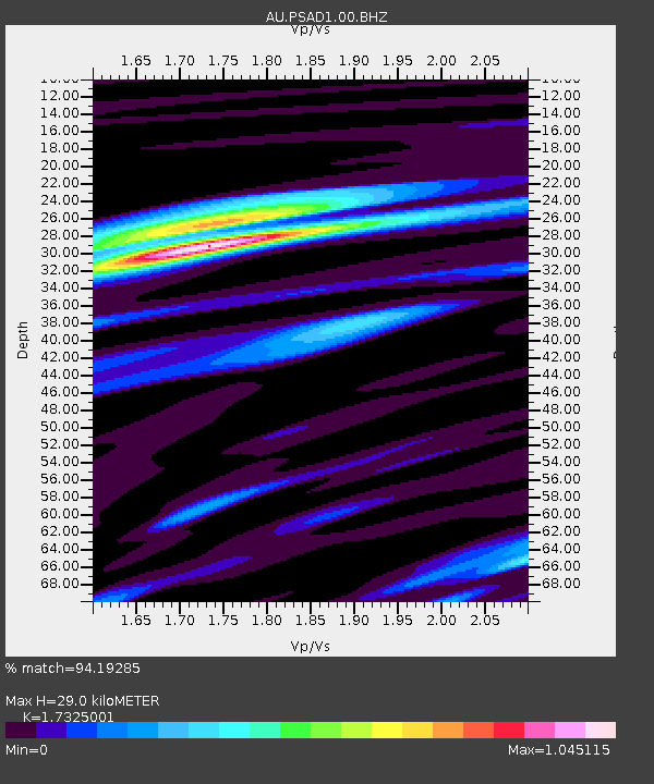
PSAD1 Pilbara Seismic Array Element D1 - Earthquake Result Viewer

Earthquake location: Fiji Islands Region
Earthquake latitude/longitude: -19.7/-177.7
Earthquake time(UTC): 2014/11/01 (305) 18:57:22 GMT
Earthquake Depth: 434 km
Earthquake Magnitude: 7.1 MWW, 6.9 MI, 7.1 MWC, 7.2 MWB
Earthquake Catalog/Contributor: NEIC PDE/NEIC COMCAT
Network: AU Australian Seismological Centre
Station: PSAD1 Pilbara Seismic Array Element D1
Lat/Lon: 21.46 S/119.83 E
Elevation: 280 m
Distance: 58.1 deg
Az: 256.502 deg
Baz: 100.417 deg
Ray Param: 0.06140153
Estimated Moho Depth: 29.0 km
Estimated Crust Vp/Vs: 1.73
Assumed Crust Vp: 6.464 km/s
Estimated Crust Vs: 3.731 km/s
Estimated Crust Poisson's Ratio: 0.25
Radial Match: 94.19285 %
Radial Bump: 376
Transverse Match: 74.08913 %
Transverse Bump: 400
SOD ConfigId: 813215
Insert Time: 2014-11-15 19:10:42.095 +0000
GWidth: 2.5
Max Bumps: 400
Tol: 0.001

Signal To Noise

ChannelStoNSTALTA
AU:PSAD1:00:BHZ:20141101T19:06:02.069021Z23.1010157.520927E-63.2556693E-7
AU:PSAD1:00:BH1:20141101T19:06:02.069021Z13.9312163.851162E-62.7644123E-7
AU:PSAD1:00:BH2:20141101T19:06:02.069021Z4.105487.159506E-71.7438902E-7
Arrivals
Ps3.4 SECOND
PpPs12 SECOND
PsPs/PpSs15 SECOND