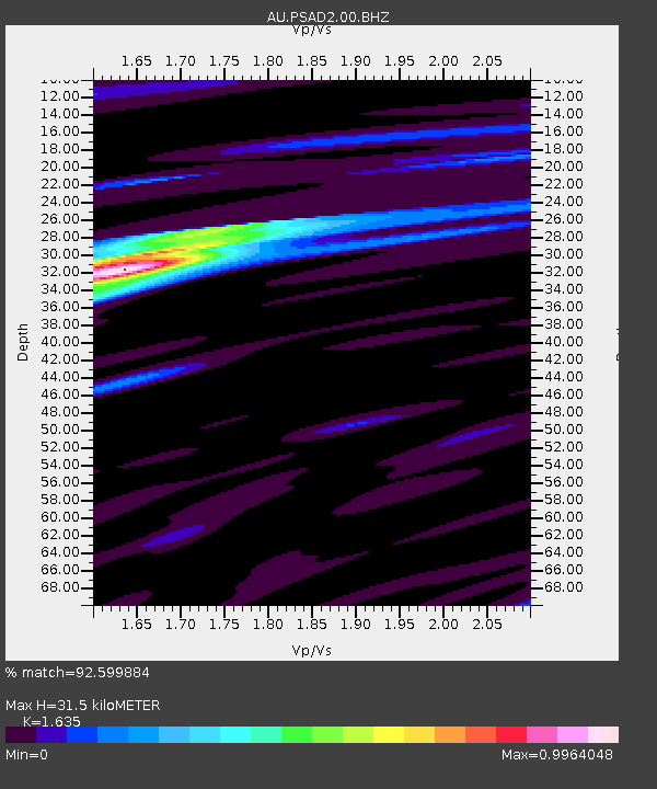
PSAD2 Pilbara Seismic Array Element D2 - Earthquake Result Viewer

Earthquake location: Fiji Islands Region
Earthquake latitude/longitude: -19.7/-177.7
Earthquake time(UTC): 2014/11/01 (305) 18:57:22 GMT
Earthquake Depth: 434 km
Earthquake Magnitude: 7.1 MWW, 6.9 MI, 7.1 MWC, 7.2 MWB
Earthquake Catalog/Contributor: NEIC PDE/NEIC COMCAT
Network: AU Australian Seismological Centre
Station: PSAD2 Pilbara Seismic Array Element D2
Lat/Lon: 21.62 S/119.96 E
Elevation: 366 m
Distance: 58.0 deg
Az: 256.341 deg
Baz: 100.284 deg
Ray Param: 0.06149714
Estimated Moho Depth: 31.5 km
Estimated Crust Vp/Vs: 1.63
Assumed Crust Vp: 6.464 km/s
Estimated Crust Vs: 3.953 km/s
Estimated Crust Poisson's Ratio: 0.20
Radial Match: 92.599884 %
Radial Bump: 400
Transverse Match: 68.19214 %
Transverse Bump: 400
SOD ConfigId: 813215
Insert Time: 2014-11-15 19:10:42.986 +0000
GWidth: 2.5
Max Bumps: 400
Tol: 0.001

Signal To Noise

ChannelStoNSTALTA
AU:PSAD2:00:BHZ:20141101T19:06:01.043997Z30.044536.6339353E-62.2080341E-7
AU:PSAD2:00:BH1:20141101T19:06:01.043997Z15.0670233.319135E-62.2029135E-7
AU:PSAD2:00:BH2:20141101T19:06:01.043997Z7.9379751.2598925E-61.5871713E-7
Arrivals
Ps3.3 SECOND
PpPs12 SECOND
PsPs/PpSs15 SECOND