You are here: Home > Network List > C - Chilean National Seismic Network Stations List
> Station GO09 Cerro Castillo, Chile > Earthquake Result Viewer
GO09 Cerro Castillo, Chile - Earthquake Result Viewer
| Earthquake location: |
Fiji Islands Region |
| Earthquake latitude/longitude: |
-19.7/-177.7 |
| Earthquake time(UTC): |
2014/11/01 (305) 18:57:22 GMT |
| Earthquake Depth: |
434 km |
| Earthquake Magnitude: |
7.1 MWW, 6.9 MI, 7.1 MWC, 7.2 MWB |
| Earthquake Catalog/Contributor: |
NEIC PDE/NEIC COMCAT |
|
| Network: |
C Chilean National Seismic Network |
| Station: |
GO09 Cerro Castillo, Chile |
| Lat/Lon: |
51.27 S/72.34 W |
| Elevation: |
372 m |
|
| Distance: |
84.1 deg |
| Az: |
142.487 deg |
| Baz: |
245.97 deg |
| Ray Param: |
0.04456672 |
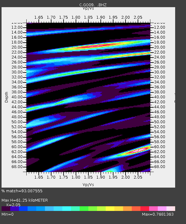
| Estimated Moho Depth: |
61.25 km |
| Estimated Crust Vp/Vs: |
2.05 |
| Assumed Crust Vp: |
6.438 km/s |
| Estimated Crust Vs: |
3.141 km/s |
| Estimated Crust Poisson's Ratio: |
0.34 |
|
| Radial Match: |
93.087555 % |
| Radial Bump: |
400 |
| Transverse Match: |
83.96792 % |
| Transverse Bump: |
400 |
| SOD ConfigId: |
813215 |
| Insert Time: |
2014-11-15 19:13:14.422 +0000 |
| GWidth: |
2.5 |
| Max Bumps: |
400 |
| Tol: |
0.001 |
|

Signal To Noise
| Channel | StoN | STA | LTA |
| C:GO09: :BHZ:20141101T19:08:34.700002Z | 29.565222 | 1.26985815E-5 | 4.2951078E-7 |
| C:GO09: :BHN:20141101T19:08:34.700002Z | 4.511646 | 1.4473881E-6 | 3.2081155E-7 |
| C:GO09: :BHE:20141101T19:08:34.700002Z | 8.1620455 | 3.9330416E-6 | 4.818696E-7 |
| Arrivals |
| Ps | 10 SECOND |
| PpPs | 28 SECOND |
| PsPs/PpSs | 39 SECOND |


