You are here: Home > Network List > IW - Intermountain West Stations List
> Station SMCO Snowmass, Colorado, USA > Earthquake Result Viewer
SMCO Snowmass, Colorado, USA - Earthquake Result Viewer
| Earthquake location: |
Fiji Islands Region |
| Earthquake latitude/longitude: |
-19.7/-177.7 |
| Earthquake time(UTC): |
2014/11/01 (305) 18:57:22 GMT |
| Earthquake Depth: |
434 km |
| Earthquake Magnitude: |
7.1 MWW, 6.9 MI, 7.1 MWC, 7.2 MWB |
| Earthquake Catalog/Contributor: |
NEIC PDE/NEIC COMCAT |
|
| Network: |
IW Intermountain West |
| Station: |
SMCO Snowmass, Colorado, USA |
| Lat/Lon: |
39.18 N/106.97 W |
| Elevation: |
3435 m |
|
| Distance: |
88.2 deg |
| Az: |
47.237 deg |
| Baz: |
242.87 deg |
| Ray Param: |
0.04172014 |
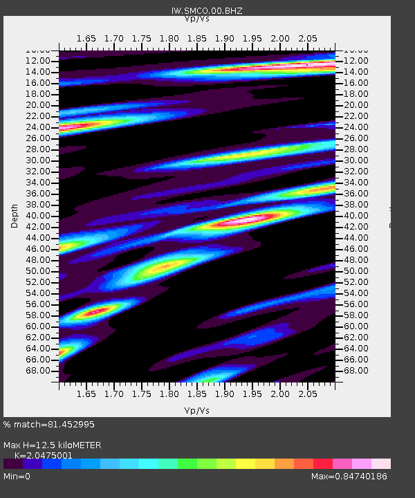
| Estimated Moho Depth: |
12.5 km |
| Estimated Crust Vp/Vs: |
2.05 |
| Assumed Crust Vp: |
6.306 km/s |
| Estimated Crust Vs: |
3.08 km/s |
| Estimated Crust Poisson's Ratio: |
0.34 |
|
| Radial Match: |
81.452995 % |
| Radial Bump: |
400 |
| Transverse Match: |
69.04088 % |
| Transverse Bump: |
400 |
| SOD ConfigId: |
813215 |
| Insert Time: |
2014-11-15 19:21:39.180 +0000 |
| GWidth: |
2.5 |
| Max Bumps: |
400 |
| Tol: |
0.001 |
|

Signal To Noise
| Channel | StoN | STA | LTA |
| IW:SMCO:00:BHZ:20141101T19:08:54.74999Z | 3.860557 | 5.006145E-7 | 1.2967416E-7 |
| IW:SMCO:00:BH1:20141101T19:08:54.74999Z | 1.5841427 | 2.3321637E-7 | 1.472193E-7 |
| IW:SMCO:00:BH2:20141101T19:08:54.74999Z | 1.3541219 | 2.5714445E-7 | 1.8989756E-7 |
| Arrivals |
| Ps | 2.1 SECOND |
| PpPs | 5.9 SECOND |
| PsPs/PpSs | 8.0 SECOND |


