You are here: Home > Network List > KG - Korean Seismic Network- KIGAM Stations List
> Station TJN Taejon, Republic of Korea > Earthquake Result Viewer
TJN Taejon, Republic of Korea - Earthquake Result Viewer
| Earthquake location: |
Fiji Islands Region |
| Earthquake latitude/longitude: |
-19.7/-177.7 |
| Earthquake time(UTC): |
2014/11/01 (305) 18:57:22 GMT |
| Earthquake Depth: |
434 km |
| Earthquake Magnitude: |
7.1 MWW, 6.9 MI, 7.1 MWC, 7.2 MWB |
| Earthquake Catalog/Contributor: |
NEIC PDE/NEIC COMCAT |
|
| Network: |
KG Korean Seismic Network- KIGAM |
| Station: |
TJN Taejon, Republic of Korea |
| Lat/Lon: |
36.38 N/127.36 E |
| Elevation: |
60 m |
|
| Distance: |
76.2 deg |
| Az: |
317.149 deg |
| Baz: |
127.438 deg |
| Ray Param: |
0.04990158 |
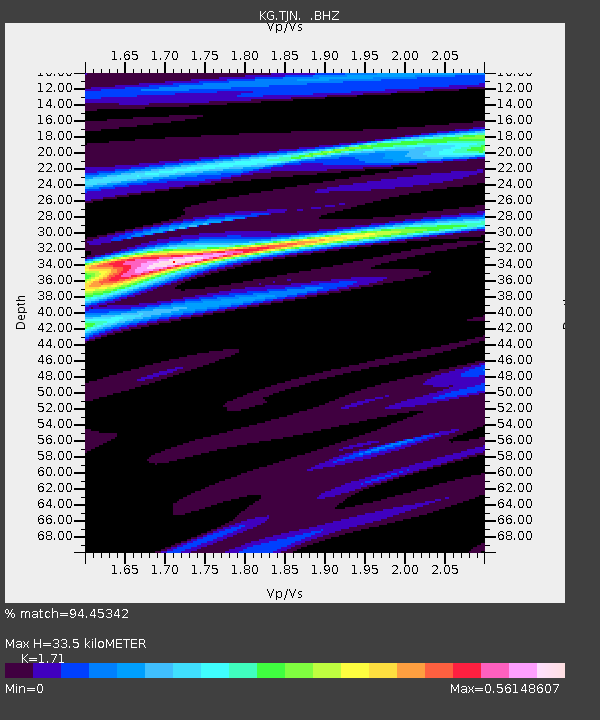
| Estimated Moho Depth: |
33.5 km |
| Estimated Crust Vp/Vs: |
1.71 |
| Assumed Crust Vp: |
6.459 km/s |
| Estimated Crust Vs: |
3.777 km/s |
| Estimated Crust Poisson's Ratio: |
0.24 |
|
| Radial Match: |
94.45342 % |
| Radial Bump: |
330 |
| Transverse Match: |
67.39006 % |
| Transverse Bump: |
400 |
| SOD ConfigId: |
813215 |
| Insert Time: |
2014-11-15 19:22:29.374 +0000 |
| GWidth: |
2.5 |
| Max Bumps: |
400 |
| Tol: |
0.001 |
|

Signal To Noise
| Channel | StoN | STA | LTA |
| KG:TJN: :BHZ:20141101T19:07:53.319021Z | 20.899754 | 2.0592322E-5 | 9.852902E-7 |
| KG:TJN: :BHN:20141101T19:07:53.319021Z | 6.633 | 5.0026574E-6 | 7.542074E-7 |
| KG:TJN: :BHE:20141101T19:07:53.319021Z | 9.4047575 | 5.9354043E-6 | 6.3110656E-7 |
| Arrivals |
| Ps | 3.8 SECOND |
| PpPs | 14 SECOND |
| PsPs/PpSs | 17 SECOND |


