You are here: Home > Network List > S - Seismographs in Schools Projects Stations List
> Station AUKAT Katherine High School, NT > Earthquake Result Viewer
AUKAT Katherine High School, NT - Earthquake Result Viewer
| Earthquake location: |
Fiji Islands Region |
| Earthquake latitude/longitude: |
-19.7/-177.7 |
| Earthquake time(UTC): |
2014/11/01 (305) 18:57:22 GMT |
| Earthquake Depth: |
434 km |
| Earthquake Magnitude: |
7.1 MWW, 6.9 MI, 7.1 MWC, 7.2 MWB |
| Earthquake Catalog/Contributor: |
NEIC PDE/NEIC COMCAT |
|
| Network: |
S Seismographs in Schools Projects |
| Station: |
AUKAT Katherine High School, NT |
| Lat/Lon: |
14.46 S/132.28 E |
| Elevation: |
122 m |
|
| Distance: |
47.9 deg |
| Az: |
268.057 deg |
| Baz: |
103.571 deg |
| Ray Param: |
0.06779278 |
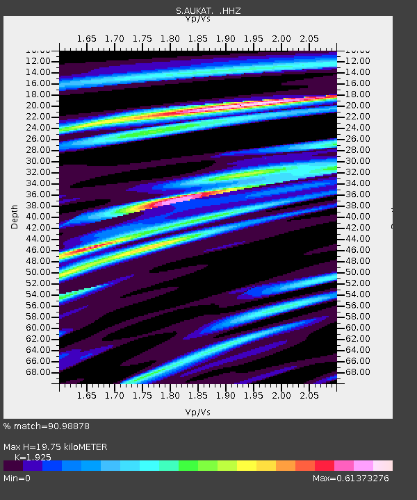
| Estimated Moho Depth: |
19.75 km |
| Estimated Crust Vp/Vs: |
1.92 |
| Assumed Crust Vp: |
6.61 km/s |
| Estimated Crust Vs: |
3.434 km/s |
| Estimated Crust Poisson's Ratio: |
0.32 |
|
| Radial Match: |
90.98878 % |
| Radial Bump: |
249 |
| Transverse Match: |
77.2641 % |
| Transverse Bump: |
400 |
| SOD ConfigId: |
813215 |
| Insert Time: |
2014-11-15 19:27:27.482 +0000 |
| GWidth: |
2.5 |
| Max Bumps: |
400 |
| Tol: |
0.001 |
|

Signal To Noise
| Channel | StoN | STA | LTA |
| S:AUKAT: :HHZ:20141101T19:04:48.99999Z | 31.54382 | 2.2404212E-5 | 7.102568E-7 |
| S:AUKAT: :HHN:20141101T19:04:48.99999Z | 8.882812 | 4.6920236E-6 | 5.282138E-7 |
| S:AUKAT: :HHE:20141101T19:04:48.99999Z | 23.055452 | 1.4868414E-5 | 6.4489797E-7 |
| Arrivals |
| Ps | 2.9 SECOND |
| PpPs | 8.3 SECOND |
| PsPs/PpSs | 11 SECOND |


