You are here: Home > Network List > TA - USArray Transportable Network (new EarthScope stations) Stations List
> Station TUL1 Leonard, OK, USA > Earthquake Result Viewer
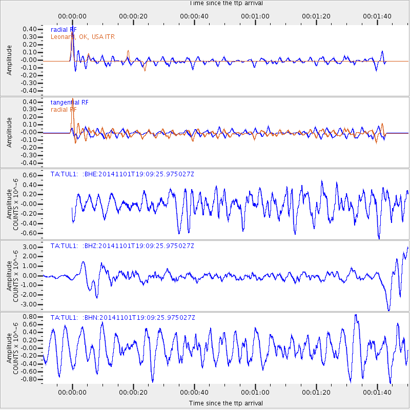
TUL1 Leonard, OK, USA - Earthquake Result Viewer
*The percent match for this event was below the threshold and hence no stack was calculated.
| Earthquake location: |
Fiji Islands Region |
| Earthquake latitude/longitude: |
-19.7/-177.7 |
| Earthquake time(UTC): |
2014/11/01 (305) 18:57:22 GMT |
| Earthquake Depth: |
434 km |
| Earthquake Magnitude: |
7.1 MWW, 6.9 MI, 7.1 MWC, 7.2 MWB |
| Earthquake Catalog/Contributor: |
NEIC PDE/NEIC COMCAT |
|
| Network: |
TA USArray Transportable Network (new EarthScope stations) |
| Station: |
TUL1 Leonard, OK, USA |
| Lat/Lon: |
35.91 N/95.79 W |
| Elevation: |
256 m |
|
| Distance: |
95.1 deg |
| Az: |
53.797 deg |
| Baz: |
249.481 deg |
| Ray Param: |
$rayparam |
*The percent match for this event was below the threshold and hence was not used in the summary stack. |
|
| Radial Match: |
71.376785 % |
| Radial Bump: |
400 |
| Transverse Match: |
36.74316 % |
| Transverse Bump: |
382 |
| SOD ConfigId: |
813215 |
| Insert Time: |
2014-11-15 19:30:21.092 +0000 |
| GWidth: |
2.5 |
| Max Bumps: |
400 |
| Tol: |
0.001 |
|
Signal To Noise
| Channel | StoN | STA | LTA |
| TA:TUL1: :BHZ:20141101T19:09:25.975027Z | 3.233517 | 7.1980185E-7 | 2.2260647E-7 |
| TA:TUL1: :BHN:20141101T19:09:25.975027Z | 1.2996888 | 3.488253E-7 | 2.683914E-7 |
| TA:TUL1: :BHE:20141101T19:09:25.975027Z | 1.5078275 | 2.0811406E-7 | 1.3802246E-7 |
| Arrivals |
| Ps | |
| PpPs | |
| PsPs/PpSs | |


