You are here: Home > Network List > US - United States National Seismic Network Stations List
> Station DGMT Dagmar, Montana, USA > Earthquake Result Viewer
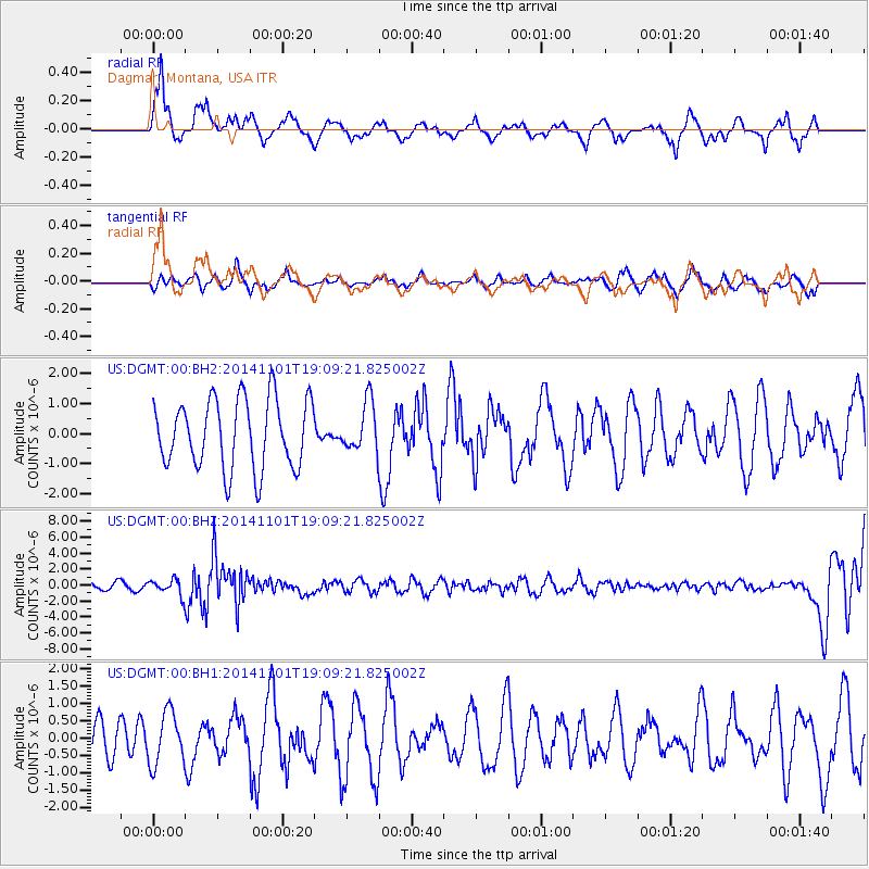
DGMT Dagmar, Montana, USA - Earthquake Result Viewer
*The percent match for this event was below the threshold and hence no stack was calculated.
| Earthquake location: |
Fiji Islands Region |
| Earthquake latitude/longitude: |
-19.7/-177.7 |
| Earthquake time(UTC): |
2014/11/01 (305) 18:57:22 GMT |
| Earthquake Depth: |
434 km |
| Earthquake Magnitude: |
7.1 MWW, 6.9 MI, 7.1 MWC, 7.2 MWB |
| Earthquake Catalog/Contributor: |
NEIC PDE/NEIC COMCAT |
|
| Network: |
US United States National Seismic Network |
| Station: |
DGMT Dagmar, Montana, USA |
| Lat/Lon: |
48.47 N/104.20 W |
| Elevation: |
0.0 m |
|
| Distance: |
94.1 deg |
| Az: |
39.783 deg |
| Baz: |
244.95 deg |
| Ray Param: |
$rayparam |
*The percent match for this event was below the threshold and hence was not used in the summary stack. |
|
| Radial Match: |
63.75619 % |
| Radial Bump: |
375 |
| Transverse Match: |
55.552006 % |
| Transverse Bump: |
340 |
| SOD ConfigId: |
813215 |
| Insert Time: |
2014-11-15 19:31:29.783 +0000 |
| GWidth: |
2.5 |
| Max Bumps: |
400 |
| Tol: |
0.001 |
|
Signal To Noise
| Channel | StoN | STA | LTA |
| US:DGMT:00:BHZ:20141101T19:09:21.825002Z | 3.082173 | 9.717892E-7 | 3.1529353E-7 |
| US:DGMT:00:BH1:20141101T19:09:21.825002Z | 0.75616664 | 7.4850146E-7 | 9.898631E-7 |
| US:DGMT:00:BH2:20141101T19:09:21.825002Z | 0.71168405 | 8.175788E-7 | 1.1487946E-6 |
| Arrivals |
| Ps | |
| PpPs | |
| PsPs/PpSs | |


