You are here: Home > Network List > UU - University of Utah Regional Network Stations List
> Station SPU South Promontory Point, UT, USA > Earthquake Result Viewer
SPU South Promontory Point, UT, USA - Earthquake Result Viewer
| Earthquake location: |
Fiji Islands Region |
| Earthquake latitude/longitude: |
-19.7/-177.7 |
| Earthquake time(UTC): |
2014/11/01 (305) 18:57:22 GMT |
| Earthquake Depth: |
434 km |
| Earthquake Magnitude: |
7.1 MWW, 6.9 MI, 7.1 MWC, 7.2 MWB |
| Earthquake Catalog/Contributor: |
NEIC PDE/NEIC COMCAT |
|
| Network: |
UU University of Utah Regional Network |
| Station: |
SPU South Promontory Point, UT, USA |
| Lat/Lon: |
41.31 N/112.45 W |
| Elevation: |
2086 m |
|
| Distance: |
85.6 deg |
| Az: |
43.34 deg |
| Baz: |
239.135 deg |
| Ray Param: |
0.04347816 |
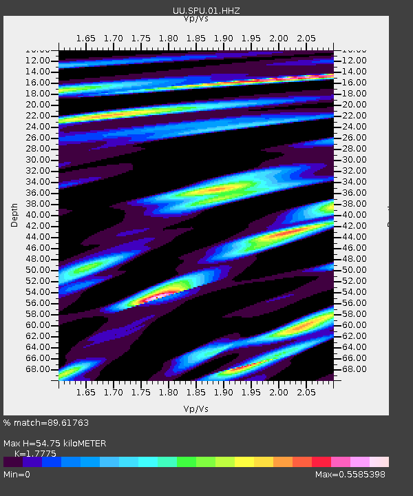
| Estimated Moho Depth: |
54.75 km |
| Estimated Crust Vp/Vs: |
1.78 |
| Assumed Crust Vp: |
6.276 km/s |
| Estimated Crust Vs: |
3.531 km/s |
| Estimated Crust Poisson's Ratio: |
0.27 |
|
| Radial Match: |
89.61763 % |
| Radial Bump: |
304 |
| Transverse Match: |
69.47495 % |
| Transverse Bump: |
365 |
| SOD ConfigId: |
813215 |
| Insert Time: |
2014-11-15 19:33:24.506 +0000 |
| GWidth: |
2.5 |
| Max Bumps: |
400 |
| Tol: |
0.001 |
|

Signal To Noise
| Channel | StoN | STA | LTA |
| UU:SPU:01:HHZ:20141101T19:08:42.304006Z | 5.030142 | 2.2021977E-8 | 4.3780033E-9 |
| UU:SPU:01:HHN:20141101T19:08:42.304006Z | 1.2820479 | 7.638574E-9 | 5.958104E-9 |
| UU:SPU:01:HHE:20141101T19:08:42.304006Z | 1.0801924 | 7.5579365E-9 | 6.996843E-9 |
| Arrivals |
| Ps | 6.9 SECOND |
| PpPs | 24 SECOND |
| PsPs/PpSs | 31 SECOND |


